This is the story of a fabled bridge, constituting not just steel and concrete, but enormous possibilities. Seven years since its foundation stone was laid, India’s longest-ever sea bridge, the Mumbai Trans Harbour Link (MTHL) is finally open to the public, significantly reducing travel time, enhancing accessibility, and contributing to the region’s overall infrastructure development, says Ivor Vaz
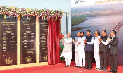
Chalk down January 12, 2024 as a red-letter day for the twin cities of Mumbai and Navi Mumbai. On a blustery winter morning, India’s Prime Minister Narendra Modi inaugurated the 22-km long Mumbai Trans Harbour Link (MTHL), a monumental infrastructure project built at a cost of ₹21,200 Crore. Christened as the ‘Atal Bihari Vajpayee Sewri-Nhava Sheva Atal Setu’, this bridge stands as the longest sea bridge in India, compares to similar sea-links in China, the US, UAE and Portugal, and ranks 12th globally.
Addressing the gathering, the Prime Minister said that the day was a historic one not only for Mumbai and Maharashtra, but also for the resolve of ‘Viksit Bharat’. “Even though these development projects are taking place in Mumbai, the entire nation’s eyes are glued to it,” he said.
Referring to the inauguration of the MTHL, the Prime Minister said that it is proof of the commitment towards India’s growth and also a symbol of accomplishment through resolution. He recalled laying the foundation stone for the bridge on December 24, 2016. Reiterating the Government commitment to completing large-scale projects, he pointed out that the citizens during the past were left despairing, owing to the negligent attitude prevalent during previous governments.
“The country will move forward and the country will progress.” This was Modi’s guarantee in 2016. The Prime Minister then declared: “I dedicate Atal Setu to Mumbaikars and the nation while bowing before Chhatrapati Shivaji, Mumba Devi, and Siddhivinayak.”
PM Modi lauded the on-time completion of MTHL Atal Setu despite the disruptions caused during the coronavirus pandemic and said that the inauguration, dedication or foundation stone laying of any development project is not a photo op but rather a medium for the creation of India. “Every such project contributes to the development of a magnificent India,” he observed.
He said that Atal Setu will fill every Indian heart with pride for the sheer size, ease of travel, engineering marvel and scale of the project. He further informed that the steel used in the project is sufficient to construct four Howrah Bridges and six Statues of Liberty. The Prime Minister thanked the Government of Japan for its assistance, while remembering late Prime Minister Shinzo Abe. “We had resolved to complete the construction of this bridge as quickly as possible,” PM Modi recalled.
“Atal Setu is the acclamation of the aspirations that the entire nation made in 2014,” the Prime Minister remarked. Recalling the time before the 2014 elections when he visited the Raigad Fort and spent time at Shivaji’s Samadhi, he said that the nation is finally witnessing the realisation of the resolutions we made 10 years ago. “Atal Setu is a reflection of this belief and it presents a picture of Viksit Bharat. It instils confidence in the youth. Viksit Bharat will consist of services and prosperity for all. It will have speed and progress which will bring the world closer. Life and livelihood will continue to flourish. This is the message of Atal Setu,” the Prime Minister concluded.
Interestingly, the Prime Minister also became the first person to officially drive across the bridge, which rises majestically in the Mumbai harbour areas, linking the island city of Mumbai with the mainland. PM Modi was flanked by Chief Minister Eknath Shinde, Deputy CMs Devendra Fadnavis and Ajit Pawar at the inauguration ceremony that expectedly attracted a huge local crowd to witness the unveiling of this giant engineering marvel.
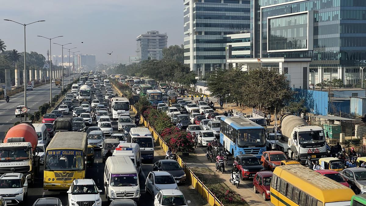
The MTHL is considered the most challenging sea bridge project taken up in India and executed by the Mumbai Metropolitan Region Development Authority (MMRDA). The bridge is expected to save commuting time from south Mumbai to Panvel (Raigad) from the existing around two hour to barely 20 minutes, leading to a massive saving in fuel costs besides reducing pollution and CO2 hazards.
Originating from Sewri in Mumbai and concluding at Chirle, near Nhava Sheva in Uran Taluka, Raigad District, the high-speed MTHL corridor will provide seamless and super-smooth connectivity to the Mumbai-Goa Highway, Mumbai-Pune Expressway, the Virar-Raigad corridor, the Navi Mumbai International Airport, the JNPA and MbPA twin ports, and serve as a new gateway to the development of the entire coastal Konkan region.
The bridge is considered an engineering marvel spanning six lanes and with a total length of 21.8 km, of which 16.5 km runs over the sea and other 5.5 km on land on both sides and elevated approach roads. To support the project’s costs, the Maharashtra government had initially approved a one-way toll of ₹250 for passenger cars using the MTHL. However, the toll rates were further reduced to ₹200 when the bridge was finally opened to the general public on January 13. Over time, the toll for round trips as well as for daily and frequent travellers will be duly computed and might vary, subject to revision after a one-year review from the start of operations, according to the Maharashtra Cabinet’s decision.
“Beyond simply reducing travel time, the bridge enhances our quality of life through the integration of modern and advanced technology. Environmental sustainability, longevity, security, and progress are among the fundamental purposes of this engineering marvel,” the MMRDA said, in an official press release, ahead of the inauguration of its biggest showpiece project.
Anticipating a significant volume of traffic in the days and months ahead, the MTHL is projected to accommodate around 70,000 vehicles daily. However, specific limitations are imposed to ensure safety and efficiency. Four-wheelers on the MTHL have a maximum speed limit of 100 km per hour, while motorbikes, autorickshaws, and tractors are prohibited from using the sea bridge.
Further guidelines include specific speed limits for different vehicle types, such as cars, taxis, light motor vehicles, minibuses, and two-axle buses. While these vehicles can travel at 100 km per hour, the speed limit is reduced to 40 km per hour on the bridge’s ascent and descent. The Mumbai Police has justified these speed restrictions as preventive measures to avoid danger, obstructions, and inconvenience to the public.
In terms of access, multi-axle heavy vehicles, trucks, and buses heading towards Mumbai are directed to use the Mumbai Port-Sewri Exit (Exit 1C) instead of the Eastern Freeway. Following this route, these vehicles will navigate through the MBPT Road near ‘Gadi Adda’ for further movement
Since the opening of the MTHL for regular traffic from January 13, the traffic snarls on both sides of the Mumbai Harbour have already been consigned to history with vehicles zipping across the bridge in barely 20 minutes without affecting the environment or the Thane Creek Flamingo Sanctuary (TCFS) below it.
So what’s the biggest takeaway from the story of this bridge, did you ask? The successful completion of the MTHL is poised to revolutionise connectivity between Mumbai and Navi Mumbai, significantly reducing travel time, enhancing accessibility, and contributing to the region’s overall infrastructure development. Touché!
MTHL – A Marvel of Modern Engineering
Here’s everything you needed to know about the newly inaugurated Mumbai Trans Harbour Link, in a nutshell…
The Mumbai Trans Harbour Link, officially named as Atal Bihari Vajpayee Trans Harbour Link and also known as Sewri–Nhava Sheva Trans Harbour Link and colloquially as Atal Setu, is a 21.8 km (13.5 mi) six lane elevated highway bridge, which connects Mumbai with Navi Mumbai, its satellite city. It is the longest sea bridge in India, and the world’s 12th longest sea bridge. The bridge begins in Sewri, South Mumbai, crosses Thane Creek north of Elephanta Island, and terminates at Chirle near Nhava Sheva in Uran Taluka, Navi Mumbai. The road is linked to the Mumbai–Pune Expressway in the east and to the under-construction Coastal Road in the west. The six lane highway is 27 metres in width, in addition to two emergency exit lanes, two edge strips, parallel crash barriers and noise barriers on both sides. The project costs a total of ₹21,200 Crore (US$2.5 billion). The bridge has a capacity to handle 70,000 vehicles per day.
A Brief History
In the 1990s, keeping the future of the Mumbai Metropolitan Region in mind, the Mumbai Metropolitan Region Development Authority (MMRDA) began studies on how to decongest the rising traffic and congestion in Mumbai, and accidents and mishaps as their direct consequences. There are currently six bridges connecting Mumbai and Navi Mumbai across the Thane Creek, but they are too narrow and outdated to handle future traffic. As a result, all of them are constrained and are carrying traffic beyond their limits, also increasing the commute time between the two cities. So, the MMRDA planned to build a comprehensive link between the two cities to handle more traffic and make travel easier, faster, safer and hassle-free. The proposal was sent to the Government of Maharashtra for consideration in 2012. In 2015, the project was approved by the Government of India and the Ministry of Road Transport and Highways (MoRTH). Hence, the foundation stone for the construction of the project was laid by Prime Minister Narendra Modi on 24th December 2016. Initially, it was expected to be completed by 2021. Then, the MMRDA awarded contracts for the project in November 2017, and construction began in April 2018, which was scheduled to be completed within 4.5 years, by 2022. However, the construction was delayed by around eight months due to the COVID-19 pandemic, and was expected to be completed by August 2023, then again by December 2023. The construction was finally completed in December 2023, and was inaugurated by Prime Minister Narendra Modi on 12th January 2024.
Land Acquisition
The project required 130 hectares of land. The City and Industrial Development Corporation (CIDCO) contributed 88 hectares. The remaining land was privately owned. According to MMRDA officials, land owners were given the same compensation package as that given in the Navi Mumbai International Airport project. 320 structures in Sewri were affected by the project, of which 250 properties were residential. The MMRDA provided resettlement for the affected people by offering accommodation in either Kanjurmarg or Kurla. The majority chose to relocate to Kanjurmarg. The MMRDA also paid ₹ 6 Lakh (US$7,500) each as compensation to 1,500 fishermen who were affected by the construction of the project. In October 2016, the MMRDA agreed to pay MbPT a total of ₹1,000 Crore in instalments over the course of 30 years, as rent for using the MbPT’s land for construction of ramps for the MTHL on the Mumbai side. The MMRDA received 27.2 hectares of land on the Sewri side of the MbPT, of which 15.17 hectares were temporarily used for the casting yard.
The MMRDA utilised drones to carry out survey work for the MTHL. The drones were fitted with 360 degrees cameras that provide up to 3 mm accuracy. The aerial survey takes less time than a regular survey, achieves greater accuracy and helps protect against false claims for compensation. Over 1,000 boreholes were drilled to study the strata. The MMRDA began conducting a geological survey for the project on 15th January 2018. The project work affected 1,635 trees, of which 753 were cut and the remaining 882 were replanted at other locations. Most of the affected trees were located at Sewri and Vakola.
Design and Alignment
MTHL is a six lane expressway bridge across Mumbai’s harbour and passes over Sewri mudflats, Pir Pau Jetty and Thane Creek channels. On the Sewri-end, a three-level interchange will connect with the under construction Sewri-Worli Elevated Corridor and Eastern Freeway. On the Navi Mumbai-end, the bridge has an interchange each at Shivaji Nagar and Chirle.
This concrete bridge features a 4 km steel span section in the middle to allow for ships to pass underneath. The longest span of MTHL is 180m and the shortest is 100m long. MTHL’s lanes have a width of 3.5m with a 2.5m wide shoulder on either side and 0.75m shoulder at the median, based on JICA’s recommendation. The maximum speed limit is restricted to 100 kmph.
MTHL features an intelligence transport system (ITS) and other amenities required for a marine bridge. The traffic conditions on the stretch are monitored and managed from a traffic control centre with the help of CCTV cameras and related facilities installed on the stretch. Variable message signs (VMS) have been installed to display appropriate information for the bridge users.
The bridge is equipped with noise barriers near Sewri mudflat area and view barriers at Bhabha Atomic Research Centre (BARC) to fulfil environmental criteria.
Metro Line
In 2010, the MMRDA appointed Rail India Technical and Economic Service (RITES) to prepare a detailed project report (DPR) for the Mumbai Trans Harbour Metro Rail Link (MTHMRL), a proposal to build a dual-track metro line under the road lanes of the MTHL. The 49 km long metro line was proposed to connect Prabhadevi and Dushmi, about
20 km away from Chirle. The metro line was to be extended to the proposed Navi Mumbai International Airport, and connected to the proposed Ranjanpada-Seawoods-Kharkopar corridor of the Navi Mumbai Metro and the proposed Sewri-Prabhadevi corridor of the Mumbai Metro. However, the MMRDA scrapped plans for the metro line in 2012, and decided to build only a road bridge. An MMRDA official stated that a detailed study has revealed that laying the foundation for the bridge with provisions for two metro lines would hike costs, instead of saving expenses. Hence, it would be feasible to have a separate bridge for the metro in the future. Another reason given was that the Navi Mumbai International Airport and Sewri-Prabhadevi corridor of the Mumbai Metro were still a long way from completion.
In June 2021, the MMRDA stated that it was re-examining the possibility of building metro lines on the MTHL. An official stated that there would be no need for extra construction on the MTHL for the metro line, as only the tracks would have to be added. Already, the Worli-Sewri underground metro corridor, as part of the Line 3 (Aqua Line) of Mumbai Metro, is being constructed. The Sewri metro station will connect the MTHL through access paths, thereby linking it to Navi Mumbai. In September 2021, the MMRDA stated that regardless of the decision on metro lines, the agency would dedicate two lanes on the MTHL for a bus rapid transit system. The agency appointed a consultant to determine whether metro lines could be constructed on the MTHL in January 2022. The draft report of the study submitted in April 2022 found that the MTHL’s existing pillars would not be able to support the load of a metro system. The then Metropolitan Commissioner of the MMRDA, S.V.R. Srinivas, stated that the agency was exploring solutions, such as increasing the load bearing capacity of the pillars, before making a final decision.
Box –
MTHL – Features
Noise and Vision Barriers
The MMRDA has installed noise and vision barriers on a 6 km section of the MTHL. The vision barriers are intended to block the view of the Bhabha Atomic Research Centre (BARC) from the MTHL, while the noise barriers are intended to protect the movement of flamingos and migratory birds at the Sewri mudflats. The MMRDA also stated that it would declare nearly 2 km of the MTHL on the Sewri side as a ‘silent zone’, as well as near schools and other sensitive areas on the Navi Mumbai side of the MTHL. Construction equipment used during the project were fitted with silencers to reduce the potential impact of noise on migratory birds such as flamingos. The project utilised reverse circulation drilling methodology which helps reduce noise levels and helps speed up construction in marine areas.
Bird Watching Platform
A 5.6 km long temporary access bridge had been built to transport equipment and workers for the construction of the MTHL. In November 2021, the MMRDA announced that it had decided against demolishing the bridge and would convert it into a bird-watching platform to view flamingos and other birds. The agency noted that the decision would also save the cost of having to demolish the bridge.
Traffic Management and Safety Measures
As an access-controlled road, to efficiently manage and regulate traffic movement across the MTHL, it has the Advanced Traffic Management System (ATMS), which is a centralised system that allows operators to monitor and manage traffic, incidents and emergency responses in real-time. Along with this, the Intelligent Transportation Management System (ITMS) is also present to systematically work with the ATMS together. This has given the bridge an international recognition for having advanced systems to manage traffic.
Like the Bandra-Worli Sea Link, due to safety considerations, two-wheelers and three-wheelers are prohibited from entering the Trans Harbor Link, along with animal-drawn carriages and slow-moving vehicles. A ban on bicycles is also in effect, though the lack of signages will make the ruling ineffective. The traffic division of Mumbai Police has mandated a speed limit of 100 km/h (62 mph) to prevent fatalities. Furthermore, stopping on the bridge is prohibited, with the exception of emergencies, breakdowns, or when pulled over by law enforcement.
Technology and Other Features
The structural steel used in the bridge is about 120,000 tonnes, enough to support the erection of four Howrah Bridges. More than 830,000 cubic metres of concrete has been used to cast the structures of the bridge, which is six times more than the quantity used for building the Statue of Unity. The reinforced steel used is 17 times the quantity used in the Eiffel Tower. The bridge is constructed using corrosion-resistant materials to withstand weather variations, high wind speeds and tides, along with natural phenomena like earthquakes and cyclones. It can withstand earthquakes up to 6.5 magnitude, thus giving the lifespan of the bridge to remain intact for over a century. The 70 spans of Orthotropic Steel Decks (OSDs) with lengths ranging from 65 to 180 metres and weighing up to 2,800 metric tons were erected across the Thane Creek using Japanese technology.
In addition, a Comprehensive Surveillance System (CSS) utilises a network of high-definition CCTV cameras strategically placed along the entire route. The Speed Violation Detection System (SVDS) has been installed to enforce speed limits and for ensuring enhanced road safety to commuters. A Video Incident Detection System (VIDS) that promptly detects and responds to incidents and mishaps has been installed. There are Emergency Calling Boxes (ECBs) on the bridge to provide commuters with a direct communication link to emergency services. Also, Variable Message Display (VMD) systems have been installed to effectively communicate and provide real-time information to commuters.
Environmental Safety and Sustainability
The roads on both sides of the bridge have been paved with stone mastic asphalt (SMA) The bridge is paved with stone matrix asphalt, which has a high percentage of crushed, durable stone aggregates and a specialised asphalt binder. SMA increases the pavement life by 20–30% because of its high resistance to variations in temperature, better adhesion between the stone aggregate and bitumen, reduces traffic noise, has high skid resistance and enhances road surface marking visibility. The surface will remain completely smooth and intact, irrespective of weather conditions. The SMA pavements will be 100% recyclable at the end of their service life, thus keeping the environment free of pollution. The carbon footprint from vehicular emissions will also significantly reduce by a few hundred thousand tons, as vehicles will be crossing the bridge at a maximum speed limit of 100 km/h (62 mph).