Your cart is currently empty!
Author: admin

30 dead, 90 injured in stampede at Maha Kumbh; Yogi Adityanath orders judicial inquiry
January 29, As many as 30 people died while 90 were left injured in a stampede at the Maha Kumbh Mela in Prayagraj early on Wednesday. The mishap occurred when devotees thronged to the Sangam area of the Maha Kumbh to take a holy dip on the occasion of Mauni Amavasya.
DIG Mahakumbh, Vaibhav Krishna, said, “30 people have lost their lives in the Maha Kumbh stampede that took place between 1-2 AM. 25 people have been identified and the identification of the remaining 5 is being done.”
The stampede forced Akharas to defer the holy dip on the auspicious day that witnessed around eight to ten crore pilgrims visiting Prayagraj. People broke open barricades to reach the location of the holy dip leading to some women fainting on the spot. The stampede began as the women fell unconscious with many of them being treated at the Bailey Hospital and Swaroop Rani Medical College currently. Uttar Pradesh Chief Minister Yogi Adityanath said, “A large number of devotees had gathered in Prayagraj since 7 PM yesterday to take a holy dip on Mauni Amavasya. An unfortunate incident took place on the Akhara Marg in which over 90 people were injured and 30 people died.” He added that the state government has ordered a judicial inquiry into the stampede.
Prime Minister Narendra Modi expressed condolences to the victims’ families and said the local administration in Prayagraj is giving all possible help to the victims and wished a speedy recovery to the injured. Later at a poll rally in Delhi, Modi said, “We lost some good souls in the tragic incident at Kumbh and some people have also got hurt. I convey my condolences to the families of those who lost their lives and pray for the early recovery of those injured”.

“I am in constant touch with the Uttar Pradesh government. Due to ‘Mauni Amavasya’, crores of devotees have reached there. For sometime, the process of bathing had been halted, but now for several hours, the yatris are taking a bath. I once again convey my condolences to the families,” he said.The Uttar Pradesh government has assigned over 1,000 medical professionals to the Maha Kumbh area and equipped each sector of the fair with facilities for both minor and major surgeries, according to an official statement. Additionally, a super-specialty hospital in Mahakumbh Nagar houses 300 specialist doctors to manage emergency situations.
Source:
www.firstpost.com
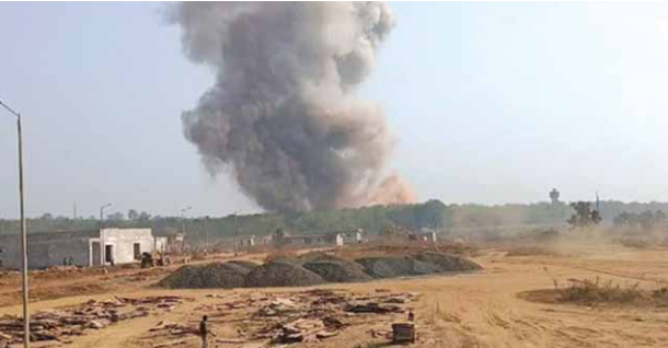
Maharashtra blast: 8 killed, 7 injured in explosion at ordnance factory in Bhandara district
Jan 24, 2025 – Maharashtra blast: At least eight people were killed and seven others injured after a blast took place at the ordnance factory in the Jawahar Nagar area of Maharashtra’s Bhandara district on Friday morning. Rescue teams including firefighters and ambulances were deployed to the site. The explosion caused the roof of the factory to collapse and earthmovers were pressed into service to clear the debris. Union minister Nitin Gadkari called the explosion an unfortunate incident, confirming 8 deaths and 7 injuries.
“A sad incident has happened. At the ordnance factory in Bhandara, an explosion took place, causing the death of eight people and injuring seven others. This is the early report. I ask everyone to stand for a minute to honor them and then we will continue with the program,” said Gadkari at an event in Nagpur.

Union defence minister Rajnath Singh expressed sadness over the blast and offered condolences to the families of the deceased and prayed for the quick recovery of the injured. Deeply saddened to know about the blast ot Ordnance Factory at Bhandara, Maharashtra. “My condolences to the bereaved families. Praying for the speedy recovery of the injured. The rescue teams are deployed at the site. All efforts are being made to provide assistance to those who are affected,” Rajnath Singh wrote in a post on X (formerly Twitter).
Source:
reuters
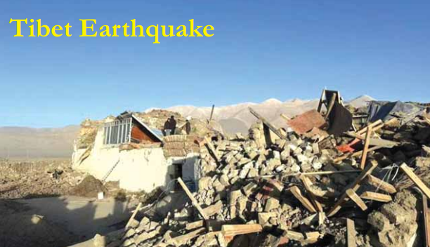
Tibet Earthquake
January 7: A magnitude 7.1 earthquake struck near Shigatse city in Tibet, resulting in at least 95 deaths and 130 injuries. The quake caused extensive damage to over 1,000 houses and affected approximately 62,000 residents. Tremors were felt as far as Nepal’s capital, Kathmandu, and the Indian state of Bihar.
On January 7, 2025, at 09:05 CST (UTC+8), a devastating earthquake measuring Mw 7.1 struck Tingri County in the Shigatse prefecture of Tibet Autonomous Region, China. The earthquake, which originated at a depth of 10 km (6.2 mi), was caused by normal faulting and became the most powerful seismic event in China since the Maduo earthquake in May 2021 and the deadliest since the Jishishan earthquake in December 2023. The tremors were felt across South Asia, impacting Nepal and northern India.
Tectonic Context
The Tibetan Plateau, formed due to the ongoing collision between the Indian and Eurasian tectonic plates, is highly seismically active. The region’s faulting mechanism includes both strike-slip and normal faulting. The earthquake’s rupture occurred on a north-south trending fault, identified as the Deng Me Cuo Fault, with a rupture length extending between Ngamring and southern Tingri County.
Casualties and Impact
The official Chinese government report cited 126 fatalities, but alternative estimates ranged from 134 to over 400. The discrepancy has fueled criticism and concerns regarding information transparency. At least 338 people sustained injuries, with 19 in critical condition. Nepal also reported 13 injuries, and minor damage occurred in northern India.
The earthquake led to the collapse of 3,612 homes and damaged over 27,200 buildings. In several villages, up to 90% of homes were razed, and infrastructure—including roads and hydropower dams—suffered significant damage. More than 40 monasteries were impacted, with eight severely affected. Telecommunications were briefly disrupted, and landslides damaged key transportation routes.
In Nepal, homes and a police station sustained damage, while avalanches near Mount Everest were reported. In Bhutan, tremors triggered two avalanches near the Bechung glacier.
Rescue and Relief Efforts
China mobilized over 14,000 rescue personnel, 340 medical workers, and extensive resources to aid the affected population. The Chinese government allocated 100 million yuan ($13.6 million) for disaster relief, deploying military personnel, drones, and satellites for damage assessment and response coordination. Emergency shelters were established, and relief supplies—including tents, warm clothing, and food—were distributed to displaced residents.
The Chinese Communist Party’s General Secretary, Xi Jinping, emphasized the urgency of rescue efforts, infrastructure restoration, and relocation assistance. Temperatures plummeting to −16°C (3°F) exacerbated the crisis, increasing the risk of hypothermia among survivors trapped under rubble.
By January 31, over 7,700 temporary shelters and nearly 10,000 tents had been set up, accommodating 47,787 displaced residents. Search and rescue operations concluded after two weeks, with authorities acknowledging the slim survival chances for missing persons due to extreme conditions.
International Response
The earthquake prompted global reactions, with leaders from more than 22 countries, the United Nations, and international organizations extending their condolences. The U.S., Denmark, and South Korea expressed sympathies via official embassy statements, while Taiwan’s Straits Exchange Foundation and Mainland Affairs Council conveyed formal messages of support. The 11th Panchen Lama initiated a donation drive that raised nearly 1.5 million yuan ($208,660) to support relief efforts.
Despite widespread solidarity, the Chinese government took action against misinformation, including administrative penalties for individuals spreading unverified fatality estimates and AI-generated images online.
Conclusion
The January 7 earthquake in Tibet stands as a tragic reminder of the seismic vulnerabilities in the region. The scale of destruction underscores the urgent need for improved earthquake-resistant infrastructure and enhanced disaster preparedness measures. While China’s rapid response mitigated further casualties, ongoing rehabilitation efforts remain critical for the thousands affected by this catastrophic event.
Source:
www.aljazeera.com
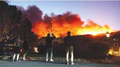
Los Angeles Wildfires
January 2025: Uncontrolled wildfires ravaged parts of Los Angeles, destroying hundreds of buildings, causing at least ten fatalities, and forcing around 180,000 residents to evacuate. The fires were fueled by strong winds and prolonged drought conditions.
Los Angeles and San Diego County, California
A series of 14 catastrophic wildfires engulfed the Los Angeles metropolitan area and San Diego County from January 7 to 31, 2025, fueled by drought conditions, low humidity, and powerful Santa Ana winds. With wind gusts reaching up to 100 miles per hour (160 km/h), the fires led to widespread destruction, claiming at least 29 lives, displacing over 200,000 residents, and consuming more than 18,000 homes and structures. In total, the wildfires burned approximately 57,000 acres (23,000 ha; 89 sq mi) of land.
Major Fires and Emergency Response
Among the most devastating fires were the Eaton Fire in Altadena and the Palisades Fire in Pacific Palisades. These two blazes, fully contained by January 31, ranked as the second and third-most destructive fires in California’s history. Firefighting efforts were led by municipal fire departments and the California Department of Forestry and Fire Protection (CAL FIRE), with both ground teams and tactical aircraft deployed to combat the flames.
Forecasted Disaster and Climatic
Conditions
The National Interagency Fire Center (NIFC) had warned of “above normal significant fire potential” as early as January 2. By January 7, the Storm Prediction Center (SPC) had issued an extreme fire weather warning for Southern California, marking multiple days of critical fire risk. As the fires spread, the National Weather Service (NWS) declared a red flag warning for Los Angeles and Ventura counties, citing dangerously dry conditions exacerbated by a transition from El Niño to La Niña, which left the region in a moderate drought by late December 2024.
Climate Change and Fire
Intensification
Scientific analyses from the Institut Pierre Simon Laplace and Climate Central indicated that anthropogenic climate change had intensified the fire conditions, contributing to increased temperatures, erratic rainfall, and prolonged dry seasons. Researchers found that rising urban temperatures and decreased precipitation heightened wildfire risks, while shifts in seasonal weather patterns extended the fire season further into the months dominated by Santa Ana winds.
Unprecedented Wind Conditions
The Santa Ana winds that fueled the fires reached exceptional speeds, with gusts recorded at 100 mph (160 km/h) on Mount Lukens and 98 mph (158 km/h) in the Santa Monica Mountains. The NWS described the windstorm as potentially “life-threatening,” with widespread power outages and downed trees reported across the region. By January 7, reports from Magic Mountain Truck Trail in Santa Clarita confirmed wind speeds of 84 mph (135 km/h), leading the NWS to compare the event to the region’s most destructive windstorm since 2011.
Compounding Human Factors
Budgetary Constraints on Firefighting Efforts
The Los Angeles Fire Department (LAFD) faced operational challenges due to a $17.6 million budget reduction for the 2024–2025 fiscal year. Fire Chief Kristin Crowley noted that these cuts severely impacted emergency response preparedness and brush clearance inspections. Additionally, rising costs and delays in acquiring new fire trucks hindered fire departments across the United States.
Aging Infrastructure and Construction Codes
Older neighbourhoods, particularly in the Palisades, suffered extensive damage due to outdated building codes. Many homes, built in the 1950s and 1960s, lacked modern fire-resistant materials, making them more susceptible to ignition.
Electric Grid Vulnerabilities
Los Angeles’ power grid was ill-equipped to handle the extreme wind conditions, with infrastructure designed to withstand only up to 56 mph (90 km/h) winds. Experts criticized the Los Angeles Department of Water and Power (LADWP) for not implementing proactive power shut-offs to prevent electrical fires.
Homelessness and Fire Incidents
A growing number of fires in Los Angeles were linked to homelessness. By 2024, an average of 46 homeless-related fires occurred daily, worsening an already precarious fire safety situation.
Water Supply Shortages
Firefighters faced critical water shortages as storage tanks in high-elevation neighborhoods were depleted faster than they could be refilled. The Santa Ynez Reservoir, a crucial water source for Pacific Palisades, had been emptied for maintenance, significantly reducing available water pressure during the emergency.
Preparation and Government Response
Governor Gavin Newsom mobilized 65 fire engines, seven helicopters, and over 100 personnel in response to the growing crisis. The Mayor of Los Angeles, Karen Bass, issued warnings to residents and coordinated emergency operations. However, as she was attending the inauguration of Ghanaian President John Mahama, acting mayor Marqueece Harris-Dawson oversaw local efforts. Utility providers, including Southern California Edison and San Diego Gas & Electric, preemptively cut power in high-risk areas to mitigate potential ignitions.
Lead-up and Early Impact
On January 7, Los Angeles declared a state of emergency. The South Coast Air Quality Management District (AQMD) issued dust storm warnings, while power outages left over 20,000 customers in the dark. The National Weather Service called the event the strongest windstorm of 2025, while the Federal Aviation Administration issued temporary flight restrictions due to hazardous conditions.
Conclusion
The January 2025 wildfires stand as one of the most severe climate disasters in recent California history. The combination of extreme wind, prolonged drought, and inadequate infrastructure response underscores the urgent need for climate-adaptive policies, improved fire management funding, and enhanced urban planning to mitigate future wildfire disasters.
Source:
www.wri.org

Melbourne Flash Floods
January 12, 2025 Severe storms caused flash flooding in Melbourne, Australia, leading to widespread damage, including downed trees and power outages affecting tens of thousands of homes.
Severe Thunderstorms Cause Flash Flooding and Disruptions Across Victoria
Melbourne, Australia – Widespread thunderstorms battered Melbourne on Sunday morning, causing flash flooding, power outages, and disruptions, including the suspension of play at the Australian Open. The Bureau of Meteorology (BOM) issued severe thunderstorm warnings for eastern parts of the state, cautioning residents about potential heavy rainfall, damaging winds, and large hailstones.
Flash Flooding and Storm Impact
Heavy rainfall led to flash flooding in parts of Melbourne’s Central Business District (CBD), with significant water accumulation at key intersections such as Russell and Lonsdale streets. The BOM recorded 24.6mm of rain at Melbourne Park within just 30 minutes, bringing the Australian Open to a standstill as spectators scrambled for cover under ponchos and umbrellas.
In the eastern part of the state, Stradbroke West recorded 29mm of rain by 3 p.m., while East Sale experienced wind gusts of up to 91kph. By 4 p.m., more than 8,000 customers across Victoria were affected by power outages, exacerbating the storm’s impact on residents and businesses.
Emergency Response and Public Safety Measures
The State Emergency Service (SES) responded to 161 requests for assistance since midnight, with its busiest units in Footscray, Malvern, and Moorabbin. Emergency responders advised residents to avoid unnecessary travel and to steer clear of hazards such as floodwaters, damaged roads, and fallen trees.
Despite an earlier severe thunderstorm warning for Melbourne, the BOM later cancelled the alert, stating that “the immediate threat of severe thunderstorms has passed, but the situation will continue to be monitored.”
Australian Open Disruptions
The adverse weather conditions severely impacted the first day of the Australian Open. Matches on outdoor courts at Melbourne Park were suspended, with no play expected before 5:30 p.m. (AEDT). However, matches continued under the closed roofs of Rod Laver Arena, Margaret Court Arena, and John Cain Arena, allowing the tournament to proceed despite the downpour.
Ongoing Weather Threats
While Melbourne’s immediate severe thunderstorm warning was lifted, BOM maintained warnings for the West and South Gippsland districts, as well as parts of the Central, East Gippsland, North East, and North Central districts. The affected areas, including Wangaratta, Bright, Morwell, Traralgon, Sale, and Maffra, remain at risk of severe storms.
With unpredictable weather patterns and the potential for further disruptions, authorities continue to monitor the situation closely. Residents and visitors are urged to stay updated through official BOM alerts and follow safety advisories to mitigate risks posed by extreme weather events.
Conclusion
Severe thunderstorms across Victoria have highlighted the vulnerability of urban infrastructure to extreme weather. The swift response from emergency services and public safety measures underscores the importance of preparedness in mitigating the impacts of climate-driven disasters. As the storm threat persists in parts of the state, vigilance and precaution remain paramount to ensuring public safety and minimizing disruptions.
Source:
www.abc.net.au
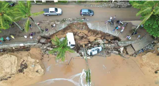
Brazil Coastal Flooding
January 15, 2025: Heavy rains caused flooding in coastal cities of southern Brazil, including Balneário Camboriú and Itapema. The floods led to the displacement of entire communities and significant damage to infrastructure.
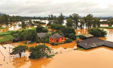
January 2025 – Vale do Aço, Brazil — The metropolitan region of Vale do Aço, located in the interior of Minas Gerais, Brazil, faced a catastrophic natural disaster between January 12 and 13, 2025, as extreme precipitation led to severe floods and landslides. The heavy rains resulted in significant devastation across the four municipalities in the region—Coronel Fabriciano, Ipatinga, Santana do Paraíso, and Timóteo—with Ipatinga experiencing the most substantial impact.
Unprecedented Rainfall and Landslides
The torrential rains, attributed to the South Atlantic Convergence Zone (ZCAS), triggered widespread flooding and landslides across the region. Ipatinga, the hardest-hit city, recorded ten fatalities caused by landslides, including two children. Coronel Fabriciano and Santana do Paraíso each reported one fatality. In total, more than 180 people were left homeless, with thousands affected by the disaster.
Rain gauges installed by the National Center for Monitoring and Early Warning of Natural Disasters (CEMADEN) reported extreme rainfall levels. In Ipatinga’s Betânia neighborhood, over 200 millimeters (7.9 inches) of rain fell within six hours, nearly equaling the city’s monthly average rainfall for January. Similar levels of rainfall were recorded in neighbouring municipalities, exacerbating the crisis.
Widespread Destruction and Infrastructure
Collapse
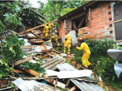
The floods caused landslides that buried homes, particularly in the neighbourhoods of Betânia, Canaã, and Vila Celeste in Ipatinga. One particularly tragic incident saw five members of a single family killed when a slope collapsed onto their home in Betânia. In Santana do Paraíso, landslides obstructed roads, cutting off access to Mesquita and Bom Jesus do Bagre.
Infrastructure damage was extensive. In Ipatinga, the Unidade de Pronto Atendimento (UPA) in the Canaã neighborhood was inundated, forcing patient evacuations to neighboring healthcare facilities. Commercial districts suffered immense losses, with Avenida José Selim de Sales, a primary business hub, heavily impacted. Even after floodwaters receded, mud and debris coated streets, homes, and businesses, hampering recovery efforts.
Public transportation and major roadways also suffered disruptions. The urban section of BR-381 was completely submerged near Shopping Vale do Aço, halting traffic. Similarly, Avenida Maanaim sustained severe structural damage due to the overflowing Taúbas stream. In Coronel Fabriciano, a slope threatened to collapse, leading to the closure of Avenida Rubem Siqueira Maia, a key roadway.
Emergency Response and Displacement
The Civil Defense issued emergency alerts to residents via mobile notifications and sirens, warning of further landslides and flooding. Despite these measures, the rapid onset of the disaster left many vulnerable. By January 15, the death toll from the broader rainy season across Minas Gerais had climbed to 26, with approximately 130 individuals left homeless in Ipatinga alone and 400 displaced. The floods affected over 85,000 people in the region by January 14.
Timóteo faced its own challenges, as a landslide isolated part of the city and flooded the Fórum Geraldo Perlingeiro de Abreu courthouse. Around 260 families in the municipality were affected, many requiring urgent assistance.
Historical Context and Urban Vulnerability
The Região Metropolitana do Vale do Aço is characterized by rugged terrain and high population density in informal urban settlements. Decades of unplanned urban expansion have forced residents to build homes near watercourses and on unstable slopes, significantly increasing their vulnerability to natural disasters. This lack of adequate land-use planning has made flooding and landslides recurrent threats.
Less than a month before the January 2025 floods, Coronel Fabriciano had already suffered a devastating storm in December 2024, which left more than 1,000 people homeless or displaced. The compounding effects of these extreme weather events underscore the urgent need for improved disaster risk management and infrastructure resilience in the region.
Looking Ahead: Recovery and Mitigation Efforts
As recovery efforts continue, local authorities and humanitarian organizations are working to provide aid to affected residents. The floods have reignited discussions on the necessity of sustainable urban planning and enhanced early-warning systems to mitigate future disasters.
The Vale do Aço floods of January 2025 serve as a stark reminder of the escalating risks posed by extreme weather events in vulnerable urban areas. With climate change expected to increase the frequency and intensity of such phenomena, a concerted effort toward disaster preparedness and resilient urban development is more critical than ever.
Source:
www.relifweb.int

Santorini Earthquake Swarm
Late January to February 2025: Over 12,000 earthquakes, mostly of small magnitude, were detected near Greece’s volcanic island of Santorini. The seismic activity prompted authorities to declare a state of emergency, leading to evacuations and heightened monitoring due to concerns about a potential larger earthquake.
The ongoing swarm of earthquakes near Santorini continues to perplex scientists while keeping disaster risk management teams and the public on high alert. Reports of the escalating seismic activity have garnered global attention. Santorini, a vast volcanic caldera with two small islets at its submerged center, has a turbulent volcanic history spanning 650,000 years. The island has experienced catastrophic eruptions, including a devastating blast around 1560 B.C. that contributed to the collapse of a civilization, a significant eruption in A.D. 726, and a moderate one in 1950. Given its active volcanic status, the region remains under close scrutiny.
Since January 31, 2025, seismic activity has surged across a 250 km² area northeast of Santorini, near the fault believed responsible for the July 9, 1956, Amorgos earthquake and tsunami. This has raised concerns among experts, who are closely monitoring the evolving situation. According to a report dated February 9, prepared by Prof. Ahmet Yalciner and a team of experts in collaboration with the National Observatory of Athens (NOA), over 1,200 earthquakes have been recorded between January 25 and February 7, with magnitudes ranging from 1.0 to 5.2. Among these, 129 earthquakes exceeded magnitude 4.0, with the strongest recorded at ML 5.2. Most quakes occurred at depths between 10 and 15 km, forming a NE-SW trending cluster east of Anydros Island.
The seismic activity is cantered within the Anydros Uplift (Anydros Horst), positioned between the NW-dipping Anydros Fault and the SE-dipping Santorini-Anafi Fault. Initial data analysis indicates an increase in earthquake magnitudes during the early phase of the swarm.
Tsunami modelling studies have been undertaken to assess potential risks associated with tectonic and volcanic activity in the region. The simulations examine possible tsunami scenarios affecting the islands of Santorini, Amorgos, Astypalaea, and Anafi, with a particular focus on the Aegean coast of Türkiye.
Growing Public Concerns and Evacuations
Denis Chang Seng, UNESCO-IOC Programme Specialist and Technical Secretary of ICG-NEAMTWS, emphasized that beyond scientific debate over the causes, a crucial issue demanding attention from disaster risk management and response teams is the self-initiated evacuation of Santorini residents. Human risk perception plays a pivotal role in such scenarios, influenced by proximity to the perceived hazard, past disaster experiences, and public trust in authorities. Although individual factors such as media coverage, age, gender, education, and income levels may not be primary drivers of risk perception, they can amplify core factors influencing public response.
According to BBC News, by February 6, over 11,000 people had fled Santorini—7,000 via ferry and 4,000 by air—due to the escalating situation. In response, Greece declared a state of emergency for Santorini on February 5, following a 5.2-magnitude earthquake at 21:09 local time (19:09 GMT) between Amorgos and Santorini. The emergency decree, effective until March 3, aims to address urgent needs and manage the situation. Greek Prime Minister Kyriakos Mitsotakis reassured the public, stating, “All plans have been implemented. Forces have been moved to Santorini and the other islands so that we are ready for any eventuality.” Despite heightened seismic activity, no significant damage has been reported on the island thus far.
The Role of the
UNESCO-IOC Tsunami Warning and Mitigation System
Amid the unfolding seismic activity, the importance of the UNESCO-IOC Intergovernmental Coordination Group for the Tsunami Early Warning and Mitigation System in the North-Eastern Atlantic, the Mediterranean, and Connected Seas (ICG-NEAMTWS) has come to the forefront. This system coordinates tsunami risk management across 40 member states with access to the Mediterranean, Baltic, North, and Black Seas. Currently, the system is designed to detect and respond to seismic-driven tsunamis, with ongoing efforts to expand its scope to include non-seismic tsunamis, such as those caused by volcanic eruptions and landslides.
To enhance coordination, the UNESCO-IOC Technical Secretary of ICG-NEAMTWS has requested its Steering Committee, composed of representatives from multiple countries, to share insights on the evolving situation. A dedicated, independent communication channel has been established between the Technical Secretary, the Hellenic National Tsunami Warning Center (HL-NTWC) at NOA, and Türkiye’s Kandilli Observatory and Earthquake Research Institute (KOERI) to facilitate the rapid exchange of critical information, particularly during nighttime and weekends.
Furthermore, NEAMTWS Tsunami Service Providers are organizing a meeting to review operational procedures and communication strategies for member states, with special attention to non-seismic tsunami events. Additionally, experts are considering a closed scientific meeting to assess the evolving seismic activity near Santorini. In response to the growing concerns, the Hellenic National Tsunami Warning Center (HL-NTWC) swiftly installed a new tide gauge station at Pori on Santorini’s northeastern coast. This new station is expected to significantly enhance sea-level monitoring and strengthen early warning capabilities.
Looking Ahead
With different schools of thought on the causes and triggers of the ongoing earthquake swarm, continued research and monitoring will be key in reaching a scientific consensus. The situation remains dynamic, and disaster risk professionals will continue to emphasize preparedness, timely communication, and proactive measures to ensure public safety in Santorini and the surrounding region.
Acknowledgments: Thanks to Dr. Nikos Kalligeris, Dr. Marinos Charalampakis (Institute of Geodynamics, NOA, Greece), Prof. Ahmet Cevdet Yalciner (Middle East Technical University, Türkiye), Prof. Dr. Nurcan Meral Özel (Director, Kandilli Observatory and Earthquake Research Institute, Türkiye), and Dr. Musavver Didem Cambaz (RETMC Deputy Director) for their insights and feedback.
Source:
www.unesco.org
Ōfunato Wildfire, Japan
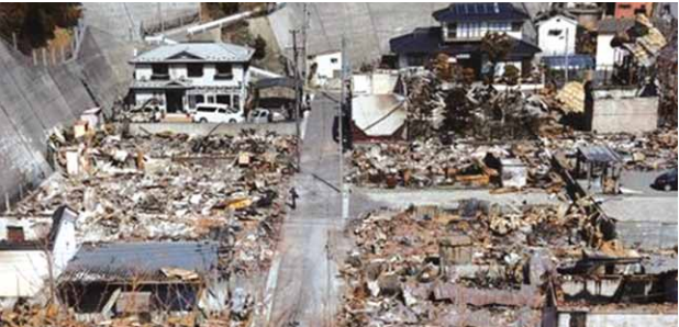
February 26 – March 9, 2025 A wildfire began in Ōfunato, Iwate Prefecture, Japan, covering a significant area before being extinguished on March 9. It destroyed 171 structures, resulted in one fatality, and forced over 4,500 people to evacuate. This was the largest wildfire in Japan in over 50 years.
Largest Wildfire in Japan in 50 Years Devastates Ōfunato
Ōfunato, Japan — A massive wildfire that broke out on February 26 in the city of Ōfunato, Iwate Prefecture, has been extinguished after burning for 12 days, marking Japan’s largest wildfire in over 50 years. The blaze, which consumed approximately 2,900 hectares (7,166 acres), destroyed 171 structures, resulted in one fatality, and forced the evacuation of 4,596 residents.
Severe Drought Conditions Fuel Disaster
The fire erupted in Akasaki Town during Ōfunato’s dry season, following Japan’s hottest recorded year in 2024. The region had received only 2.5 mm of rainfall in February-a historic low compared to the 41 mm average. Experts attributed the rapid spread of the fire to the area’s dry conditions, steep mountainous terrain, and highly flammable coniferous trees.
Fire’s Rapid Spread and Evacuation Orders
The wildfire was first reported at 1:02 p.m. on February 26. Within hours, evacuation orders were issued, initially affecting the Ryōri area. By the evening, the fire had expanded to 600 hectares, with 84 structures damaged and more than 2,000 people displaced.
As the fire raged on, authorities extended evacuation orders to multiple districts. By March 1, nearly 1,900 households had been affected, with the blaze spreading to 1,400 hectares. The fire continued growing, reaching 2,900 hectares by March 5. The following day, authorities confirmed that it had surpassed Japan’s previous record for wildfire size, set in Hokkaido in 1975.
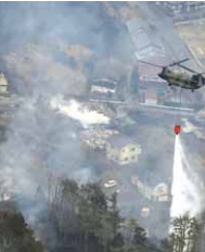
Efforts to Contain the Fire
Firefighters from 15 prefectures, totalling 2,030 personnel, along with 13 aerial firefighting teams, battled the flames. The Japan Self-Defence Forces were deployed, and disaster relief measures were enacted to aid displaced residents.
Rainfall on March 5 provided a crucial break in firefighting efforts, although officials noted that the fire remained a threat. Evacuation orders were lifted gradually, with 957 residents allowed to return on March 7, and the final orders lifted on March 10.
Casualties and Impact
The fire claimed the life of a 90-year-old man whose body was discovered on February 27. In addition to the 171 structures destroyed, another 39 buildings sustained damage. Electricity was cut to 500 households, and several schools and businesses, including Taiheiyo Cement’s Akasaki plant, suspended operations. Transportation was also disrupted, with sections of Sanriku Railway closed and road access restricted.
The fishing industry suffered significant losses, with multiple processing plants destroyed and fishermen losing vital equipment. Additionally, nearly 3,000 chickens perished due to lack of food and water while their facilities were inaccessible.
Government Response and Recovery Efforts
The Japanese government declared the wildfire a “severe disaster,” unlocking financial assistance for rebuilding efforts. Prime Minister Shigeru Ishiba pledged support for affected communities. By March 6, Ōfunato had received over 3,600 donations, amounting to approximately ¥160 million (US$1.46 million), with contributions from high-profile figures, including baseball star Roki Sasaki and the Los Angeles Dodgers.
With the fire now fully contained, recovery efforts are underway to rebuild homes, businesses, and infrastructure in Ōfunato. The cause of the wildfire remains under investigation.
Source:
www.nippon.com

Eight Places You Must Visit in Brazil
There is an abundance to see and do in Brazil. Here are eight must-visit destinations in this Latin American paradise:
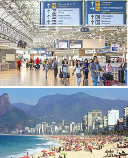
Rio de Janeiro
With over 450 years of history, Rio de Janeiro is a unique city that beautifully combines its geographic features—such as the sea, mountains, and forests—with vibrant human presence. To truly experience the energy of Brazilian culture, nothing compares to enjoying Carnival in Rio. Among the city’s most famous attractions are Sugarloaf Mountain, Christ the Redeemer, and Tijuca National Park. The Sugarloaf Cable Car, which operates at an altitude of 396 meters above sea level, connects Urca Mountain to Sugarloaf Mountain. Christ the Redeemer, with its open arms over Guanabara Bay, stands majestically on top of Corcovado Mountain, making it the largest and most renowned Art Deco sculpture in the world.


Commonly known as Sampa, São Paulo is a city that never sleeps. From theatrical performances and cultural exhibits to 24-hour bars and restaurants, visitors can always find something to do. The city shares its name with the state and boasts countless movie theatres, cultural centres, museums, historic buildings, parks, theatres, and art galleries. São Paulo’s nightlife is frenetic, creative, and inclusive, earning it a place among CNN’s list of the ten best places in the world for parties and nightlife. Additionally, the city is regarded as the Latin American capital of fine cuisine, featuring high-end international restaurants and sophisticated regional dishes crafted by renowned Brazilian chefs.
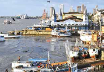
Belém
Belém, the capital of Pará, is a charming destination known for its beaches, forests, and historic heritage as well as modern tourist attractions. One of Belém’s main local highlights is a cultural complex called Estação das Docas (Wharf Station), which offers a variety of local cuisine, culture, fashion, and handicrafts. Visitors can enjoy performances of the carimbó, a traditional dance with Indigenous and African roots. As Belém is situated in the Amazon region, adventure seekers can explore trails in the forest or take boat rides to discover other beautiful beaches and islands in the region, such as Marajó, an island renowned for its natural beauty.
Manaus
Nestled in the heart of the Amazon Forest, Manaus is a city that boasts stunning architecture from the Rubber Boom era. The Amazonas Theatre, with its colourful dome adorned with 36,000 enamelled ceramic tiles, is a standout attraction. As the capital of Amazonas, Manaus serves as the main metropolitan hub of the region and is the natural gateway for exploring the Amazon Forest. Boats are the primary means of transportation to rainforest hotels and to witness the confluence of the Rio Negro and Solimões Rivers. Visitors can also observe Amazon River dolphins in Anavilhanas and visit places such as Moon Beach. Experience local gastronomy while touring the vast rivers and narrow streams that connect to riverside communities.

Foz do Iguaçu
In addition to the incredible Iguaçu Falls, Foz do Iguaçu boasts several attractions that will surely captivate you. Located in the extreme west of the State of Paraná, it is one of the icons of Brazilian tourism, thanks to the 275 majestic waterfalls that make up Iguaçu Falls. Situated in Iguaçu National Park, on the border between Brazil and Argentina, these Falls attract millions of visitors from around the world. Having earned a spot on the UNESCO World Natural Heritage List, the park’s stunning waterfalls were also voted one of the ‘World’s New Seven Wonders of Nature.’ Lonely Planet describes it as one of the top ten must-see places in the world, stating, “It’s an emotionally jaw-dropping experience. Everyone should see it at least once in their lifetime!”

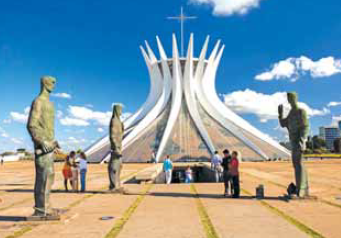
Brasília
Brasília, Brazil’s third capital city, was planned just over 60 years ago, and its beauty lies in its intricate details, designs, and colours. Following Salvador and Rio de Janeiro, this audacious project has become a symbol of urban planning and modern architecture in the 20th century. Home to more than three million people, Brasília’s design, known as the Pilot Plan (Plano Piloto), was conceived by urban planner Lúcio Costa and architect Oscar Niemeyer. The layout resembles the shape of an aeroplane and has been included on UNESCO’s World Cultural Heritage List. Notably, Brasília is the city with the largest area on the Heritage List in the world. Its architecture stands apart from anything you have ever seen.
Fortaleza
Fortaleza, the capital city of Ceará in northeastern Brazil, has something for everyone. In addition to its countless stunning beaches, the city boasts a rich culture, delicious local cuisine, wonderful handicrafts, and beautiful architecture. Fortaleza offers various leisure options, including museums, theatres, handicraft markets, and a vibrant nightlife. Iracema Beach is a lively area where culture thrives, featuring movie theatres, a planetarium, and the Museum of Contemporary Art at the Dragão do Mar Centre of Culture and Arts. It becomes a bustling hub in the evenings with numerous bars, nightclubs, and live music. Visit the Central Market to take home an authentic souvenir from the city.


Salvador
The capital of the State of Bahia, Salvador, is renowned for its natural beauty and the strong influence of African culture. The Historic Centre of Salvador is where visitors can explore streets and architectural monuments dating back to Colonial Brazil, the Empire, and the First Republic. This culturally rich area includes the neighbourhoods of Sé, Pilar, and Pelourinho, which house historical monuments from the 17th, 18th, and 19th centuries. It is a popular destination for tourists seeking museums, theatres, churches, musical performances, local cuisine, and handicrafts. Salvador is home to more than 300 churches, including the São Francisco Church and Convent, classified as one of the Seven Wonders of Portuguese Origin in the World, and listed on the National Institute of Historic and Artistic Heritage List.

Brazil: Where Heaven Meets Earth
With its breathtaking waterfalls, vibrant culture, unique cuisine, some of the world’s most stunning beaches, and thrilling adventures, Brazil offers a variety of tourism experiences tailored to every preference. Prepare to be amazed by the wonders of this captivating country, as promised by Ivor Vaz.
Brazil, often regarded as one of the most underrated travel destinations globally, is a treasure trove of experiences waiting to be uncovered. While it is already a popular destination for tourists, with tourism playing a pivotal role in its economy, the country’s true essence remains underexplored. Iconic destinations such as Rio de Janeiro, Santa Catarina, São Paulo, Minas Gerais, Iguazu Falls, and the Pantanal offer unforgettable experiences for every traveller.
In 2023, Brazil welcomed 5,908,341 foreign visitors, a 62.7% increase from 2022 and just shy of the 6.3 million recorded in 2019 before the pandemic. These figures, reported by Embratur, the Ministry of Tourism, also exceeded the World Tourism Organization’s projections for Brazil by 3%.
Diverse Landscapes
Brazil boasts an astonishing variety of landscapes, from the lush Amazon Rainforest and pristine beaches of Rio de Janeiro to the vast Pantanal wetlands and the awe-inspiring Iguazu Falls. This diversity offers travellers a range of experiences, making it a paradise for nature lovers and adventurers alike.

Cultural Riches
Brazil’s cultural fabric is a vibrant mosaic woven from indigenous heritage, Portuguese colonial influences, and contributions from African, European, and Asian immigrants. This unique blend is reflected in its music, dance, art, and cuisine. Events like Rio de Janeiro’s Carnival, samba rhythms, and regional festivals celebrate the country’s rich cultural heritage.
Warm Hospitality
Renowned for their warm and welcoming nature, Brazilians create an inviting atmosphere that enhances the travel experience. Visitors often find themselves embraced by the genuine warmth of the locals, creating an inviting atmosphere that enhances the overall travel experience. The sense of community and the willingness to share their traditions make Brazil a welcoming destination.
Epicurean Delights
Brazilian cuisine is a delightful fusion of flavours and traditions. From the famous churrasco (barbecue) to feijoada (a hearty black bean stew), the culinary landscape caters to every palate. Food enthusiasts can explore bustling markets and street stalls to savour the authentic flavours of Brazil’s gastronomic wonders.
Adventure Opportunities
Brazil offers endless opportunities for thrill-seekers. Whether trekking through the Amazon, surfing in Florianópolis, or exploring the dramatic landscapes of Chapada Diamantina, adventure awaits at every turn for those seeking an adrenaline rush.
Affordability
Surprisingly budget-friendly, Brazil provides excellent value for travellers. Accommodations, meals, and activities are often more affordable than other global destinations, allowing visitors to maximise their experiences without overspending.

Off-the-Beaten-Path Gems
For those willing to venture beyond the iconic attractions, Brazil reveals hidden gems beyond the well-known attractions. Remote beaches, charming colonial towns, and untouched natural wonders await discovery.
Brazil’s status as an underrated travel destination underscores the vastness of its offerings, waiting to be explored by those seeking unique and enriching experiences. As you plan your next adventure, consider Brazil—a destination poised to exceed your expectations and leave you with memories to last a lifetime.