Your cart is currently empty!
Category: Case Study
Urban Flooding in Mumbai: Lessons from 2024
Rutuj Mahendra Salunke is a master’s graduate in Disaster Management from the Tata Institute of Social Sciences (TISS). With a deep understanding of disaster risk reduction and resilience, Rutuj brings significant field experience from both urban and rural settings. He currently works as an assistant editor for the Known Disasters Magazine, contributing his expertise in content creation, editing, and disaster-related journalism.
In this article, we will explore the challenges of urban flooding in Mumbai, particularly highlighted by the events of 2024, and examine potential solutions to improve flood management. We will discuss the role of citizen science, crowdsourced data, and advanced technology in enhancing real-time flood monitoring and mitigation. Additionally, we will highlight the importance of integrating these modern approaches with traditional infrastructure to create more resilient systems, ensuring Mumbai is better prepared to face future floods in the wake of climate change.
Urban Flooding in Mumbai: Lessons from 2024
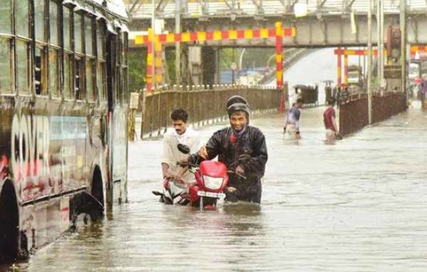
Mumbai, one of the largest and most densely populated cities in India, has long been susceptible to urban flooding due to a combination of intense monsoon rains, inadequate drainage systems, and rising sea levels. In 2024, the city once again experienced severe flooding, bringing to the forefront the urgent need for more effective and accessible flood monitoring and mitigation strategies. Despite efforts by the Brihanmumbai Municipal Corporation (BMC), gaps remain in creating a robust and citizen-friendly early warning system. This article delves into the challenges Mumbai faces in managing floods and explores potential solutions using crowdsourced data and citizen science.
Every Monsoon, Mumbai braces itself for floods, a recurring event that has plagued the city for decades. While the Brihanmumbai Municipal Corporation (BMC) has implemented several measures that have reduced flooding in certain areas, the problem still persists. Why?
Mumbai’s vulnerability to floods stems from a combination of geographical, infrastructural, and climatic factors. Built on a collection of seven islands, the city’s reclamation projects have created low-lying coastal tracts. Many of these areas sit just 1 meter above sea level or even below the high tide level, making them particularly prone to flooding. This, combined with outdated drainage systems and increasing climate variability, sets the stage for the city’s annual struggle with monsoon floods.
Why Does It Flood in Mumbai?
The answer is multifaceted. According to the Flood Preparedness Guidelines 2023, three primary factors contribute to flooding in the city:
1. Localized flooding due to inadequate drainage systems.
2. Overflow from the Mithi River, especially during heavy rains.
3. A combination of high tides and high river flows, which exacerbate flooding in coastal areas.
Mumbai’s drainage system, designed decades ago, is no longer equipped to handle the intensity and frequency of modern rainfall patterns. Originally constructed to manage 25 mm of rainfall per hour, the system is overwhelmed during heavy downpours. An official from BMC’s Storm Water Drains (SWD) Department explained that while the drains are designed for moderate rainfall spread over time, the city now often experiences intense rainfall over short periods, leaving the system unable to cope with the water volume.
The Role of Citizen Science in Urban Flood Management
Citizen science plays a critical role in enhancing urban flood management by empowering local communities to actively contribute to real-time monitoring and data collection. In densely populated cities like Mumbai, where traditional flood forecasting systems often face limitations, citizen science offers a practical and scalable solution. Citizens, through the use of mobile phones, social media platforms, and other accessible technologies, can report on-the-ground conditions such as water levels, flood locations, and blocked drains. This crowdsourced information can fill crucial gaps in official data and provide authorities with valuable insights into how floods are impacting specific areas in real time.
One of the major advantages of integrating citizen science into urban flood management is its ability to generate hyper-localized data. In many cases, official systems struggle to capture flooding at a street or neighbourhood level, but citizens can provide granular details from their immediate surroundings. For example, platforms like Twitter have been effectively used to gather reports of waterlogging and floods in Mumbai, enabling authorities to respond more rapidly to emerging issues. When combined with other technologies such as geographic information systems (GIS) and satellite data, this citizen-generated information can significantly enhance the accuracy of flood monitoring and forecasting.
Moreover, citizen science fosters a sense of ownership and community engagement in managing urban floods. When residents are involved in the data collection process, they become more aware of flood risks and proactive in mitigating them. Programs that train volunteers to act as live sensors, as seen in some parts of Mumbai, have not only improved the quality of flood-related data but also created a more informed public. These volunteers, equipped with mobile apps and tools like WhatsApp or Google forms, provide real-time updates on flood-prone areas, helping local authorities prioritize their responses.
Beyond real-time monitoring, citizen science can also contribute to long-term flood resilience planning. Crowdsourced data helps identify chronic flood hotspots and evaluate the effectiveness of mitigation measures over time. By analyzing trends in waterlogging reports and comparing them with rainfall patterns, decision-makers can adjust strategies to better protect vulnerable areas. This data-driven approach supports more efficient resource allocation and infrastructure investments, ultimately leading to more resilient urban environments.
Incorporating citizen science into urban flood management thus holds tremendous potential for improving preparedness and response in cities like Mumbai. As climate change continues to increase the frequency and intensity of extreme weather events, leveraging the collective knowledge and experience of citizens will be essential for building adaptive, community-centered flood management systems.
However, the reliance on citizen science and social media for real-time flood monitoring highlights a key gap: Mumbai still lacks a dependable, end-to-end flood forecasting and early warning system. While BMC’s efforts have led to reduced flooding in certain areas, the absence of a comprehensive, citizen-accessible system limits the city’s ability to plan for and respond to floods effectively.
The Future of Flood Forecasting: Citizen Science as a Solution
As climate change intensifies the frequency, duration, and severity of extreme weather events, innovative approaches to disaster risk reduction will become increasingly important. The Intergovernmental Panel on Climate Change (IPCC) report emphasizes the need for community-based solutions in urban areas. The integration of crowdsourced data, as demonstrated in this study, shows significant promise in contributing to modern decision-making systems for urban flooding.
By leveraging advanced techniques such as sentiment analysis and natural language processing, crowdsourced data can be harnessed more effectively to generate reliable early warning systems. When citizens see their contributions being used to save lives, their involvement is likely to increase, further enhancing the accuracy and usefulness of the data.
Lessons from 2024: Mitigation Strategies in Action
The floods of 2024 have provided a critical learning opportunity, shedding light on both the successes and shortcomings of Mumbai’s flood mitigation strategies. One of the most significant lessons from recent years is the observable decline in waterlogging reports, particularly between 2020 and 2022, despite sustained and sometimes intense rainfall. This trend suggests that the city’s proactive flood management measures have been partially successful. The decrease in reported flood incidents was further validated through systematic surveys conducted at various known flood hotspots. Local authorities confirmed the effectiveness of many of the implemented measures, reinforcing the idea that while challenges remain, progress has certainly been made.
One of the key strategies contributing to these successes has been the installation of advanced pumping systems in flood-prone areas. Public used to witness severe flooding on street, improvements such as water pumps have made a tangible difference. The experience of floods diminishing in frequency, except during particularly heavy rains, echoes the broader findings of reduced waterlogging in many other areas of Mumbai. This improvement can be attributed to a more comprehensive approach to managing stormwater, which includes clearing drainage systems and maintaining pumping stations.
The Brihanmumbai Municipal Corporation (BMC) deserves recognition for its proactive flood management efforts, which have greatly reduced the loss of life and damage to property in recent years. The BMC’s focus on addressing waterlogging hotspots, reducing them from 440 to 84 over time, is commendable and indicates that their strategies are working in many parts of the city. These efforts have also included the expansion and maintenance of stormwater drainage networks, which are essential for preventing the rapid accumulation of water during heavy rainfall events.
Despite these strides in flood mitigation, one of the most critical gaps still remains: the lack of an end-to-end, real-time flood forecasting system that is easily accessible to the public. While BMC’s efforts in reducing waterlogging have shown progress, the absence of an integrated early warning system severely limits Mumbai’s ability to respond to sudden, extreme weather events. The 2024 floods have made it clear that without a comprehensive, real-time monitoring system, both authorities and citizens are left at a disadvantage when it comes to planning for and responding to floods.
Looking forward, the lessons from 2024 underline the need for continued investment in flood management systems that are dynamic, data-driven, and accessible to the public. The integration of technology, citizen science, and real-time data will be key in ensuring that Mumbai becomes more resilient to future floods, especially in the face of climate change, which is expected to increase the frequency and intensity of extreme rainfall events. A modern flood forecasting system, built on these principles, could significantly reduce the impact of future floods on one of the world’s most densely populated cities.
What Lies Ahead?
The future of flood management in Mumbai lies in integrating traditional mitigation measures with advanced technological solutions. The Intergovernmental Panel on Climate Change (IPCC) report emphasizes the importance of community-based solutions in disaster risk reduction. Crowdsourced data, as explored in this study, offers a promising way to fill the gaps in real-time flood monitoring.
In the coming years, leveraging data from platforms like Twitter and VGI can help authorities develop street-level flood forecasting systems. By combining this data with numerical and physics-based models, Mumbai could create a modern decision system that allows for more precise and effective flood responses. As the city continues to face the challenges posed by climate change, such systems will become increasingly crucial. The events of 2024 serve as a stark reminder of Mumbai’s vulnerability to urban flooding, yet they also highlight the potential for transformative solutions. The integration of citizen science, crowdsourcing, and advanced technology presents a promising pathway toward more efficient flood management. While mitigation strategies have led to significant improvements, such as a reduction in waterlogging hotspots and minimized losses, critical gaps remain—particularly the need for a real-time, end-to-end flood forecasting system accessible to the public. By harnessing the power of crowdsourced data and combining it with cutting-edge technology like numerical modeling, Mumbai can develop more resilient flood management systems. The use of platforms such as Twitter and Volunteered Geographic Information (VGI) has already proven effective in identifying flood-prone areas, providing granular, real-time data to inform decision-making. With continued investment in both traditional infrastructure and technological innovation, the city can minimize the impacts of future floods, transforming crowdsourced data into life-saving early warnings, and ensuring that urban areas are better prepared to face the growing challenges posed by climate change.
Flood Management in Kerala: A Model for Disaster Resilience
Appu KG is a dedicated disaster management professional who has earned a Master’s degree in Disaster Management from the prestigious Tata Institute of Social Sciences (TISS). With a strong academic foundation and a wealth of practical experience, Appu has honed his expertise in disaster risk reduction, emergency
response, and resilience-building strategies. His fieldwork spans across diverse regions, where he has
actively contributed to disaster preparedness and recovery efforts, showcasing his commitment to safeguarding vulnerable communities. Appu’s comprehensive understanding of disaster dynamics and his hands-on experience make him a valuable asset in the field of disaster management.This article explores Kerala’s evolution into a global model for flood management and disaster resilience, particularly after the devastating floods of 2018. It highlights the state’s strategic approach, which includes the use of modern technology such as real-time flood monitoring systems, early warning mechanisms, and drones for damage assessment. Community participation, policy reforms, and environmental conservation efforts have also played crucial roles in building long-term resilience. By examining these initiatives, the article showcases how Kerala has successfully transformed its flood management framework to better protect lives, livelihoods, and the environment.
Floods are one of the most severe and frequent natural disasters globally, often leading to devastating consequences for human lives, property, and the environment. Kerala, a southern Indian state, has been particularly vulnerable to floods due to its geographical location, dense river network, and tropical climate. In recent years, Kerala has experienced severe floods, with the 2018 and 2019 monsoon floods leaving behind a trail of destruction. However, these calamities also prompted a significant shift in how Kerala approached flood management, resulting in a more disaster-resilient model that has gained international recognition.
Kerala’s model for flood management has evolved over time, integrating technology, policy reforms, community participation, and environmental conservation. This article examines the state’s transformation from a flood-prone region to a global example of disaster resilience. We will explore how Kerala has effectively responded to floods, improved preparedness, and developed sustainable strategies to manage the long-term impact of such natural disasters.
Geographical and Climatic Vulnerability of Kerala
Kerala’s geographical position, nestled between the Arabian Sea on the west and the Western Ghats on the east, makes it particularly prone to floods. The Western Ghats, a mountain range that runs parallel to the coast, receive heavy rainfall during the monsoon season, leading to high water levels in Kerala’s numerous rivers and lakes. This topographical structure, coupled with a tropical monsoon climate, makes Kerala highly susceptible to flooding, especially during the southwest monsoon from June to September.
The state’s unique landscape also includes a network of rivers, lakes, and backwaters, which further increase the risk of floods. With 44 rivers crisscrossing the state, the risk of riverine flooding is high during intense monsoon rains. Several regions, such as Kuttanad in Alappuzha district, lie below sea level, making them particularly vulnerable to floods.
However, while Kerala’s topography and climate contribute to its flood vulnerability, human activities such as unregulated construction, deforestation, and poor urban planning have exacerbated the impact of floods. The rapid expansion of urban areas, often without adequate drainage infrastructure, has led to increased waterlogging during heavy rains, further intensifying the problem.
The 2018 Kerala Floods: A Disaster That Changed Everything
The 2018 floods in Kerala were among the worst in the state’s history, marking a turning point in its approach to disaster management. Unusually high monsoon rainfall, coupled with the mismanagement of dam water releases, led to catastrophic flooding across most of the state. Heavy rains caused several rivers, including the Periyar and Pamba, to overflow, submerging large areas and affecting almost all districts of Kerala.
More than 400 people lost their lives, and over a million residents were displaced from their homes. The floods caused widespread destruction of infrastructure, homes, agricultural land, and public utilities, with the economic loss estimated at around Rs 40,000 crores (approximately $5.5 billion). Entire towns and villages were inundated, with essential services like transportation, healthcare, and education coming to a standstill.
The disaster highlighted several critical gaps in Kerala’s flood management system:- Inadequate Early Warning Systems: There was a lack of accurate early warning systems that could provide timely information about impending floods.
- Mismanagement of Dam Releases: The release of water from dams during peak rainfall periods contributed significantly to the floods.
- Unregulated Urbanization: Rapid urban growth, without sufficient planning for drainage and flood prevention, exacerbated the impact of the floods.
Despite the devastation, the 2018 floods served as a wake-up call for Kerala. The disaster acted as a catalyst for change, leading to a comprehensive reassessment of the state’s flood management policies and practices. - Technology-Driven Solutions: Modernizing Flood Management
One of the significant shifts in Kerala’s flood management strategy has been the adoption of modern technology to improve flood forecasting, monitoring, and early warning systems. The use of technology has significantly enhanced the state’s ability to predict and respond to floods, minimizing the damage and loss of life.
Real-Time Flood
Monitoring Systems
Post-2018, Kerala has implemented real-time flood monitoring systems that utilize satellite data, Geographic Information System (GIS) mapping, and hydrological models. These systems allow authorities to monitor water levels in rivers, lakes, and dams in real-time, providing early warnings about potential flooding.
The Kerala State Disaster Management Authority (KSDMA) has worked closely with organizations like the Indian Space Research Organisation (ISRO) to develop accurate models that can predict rainfall patterns and river flows. These models use data from weather satellites and ground-based sensors to generate real-time information on water levels and potential flood risks. This data is crucial for decision-making during the monsoon season, allowing local authorities to take preventive measures such as issuing evacuation orders and preparing emergency shelters.
Early Warning Systems
The introduction of early warning systems has been a game-changer in Kerala’s flood preparedness. These systems provide timely alerts to local authorities and the public about the possibility of floods. The KSDMA issues alerts based on real-time data, which are disseminated through multiple channels, including SMS, social media, and radio broadcasts.
Early warning systems are particularly important for communities living in flood-prone areas, as they allow residents to evacuate in advance and take necessary precautions to protect their homes and belongings. The ability to receive real-time updates has significantly improved Kerala’s disaster preparedness, reducing the impact of floods on human lives.
Drone Technology for Post-Flood Assessment
Drones have become an essential tool in post-flood assessment and rescue operations in Kerala. After a flood, drones are deployed to capture aerial footage of affected areas, providing authorities with a clear view of the damage. This technology is particularly useful in areas that are difficult to access by road due to waterlogging or collapsed infrastructure.
The use of drones allows for quicker and more accurate assessments of the damage, enabling authorities to prioritize rescue and relief operations. Drones are also used to identify areas where relief supplies, such as food and medical aid, are most needed, ensuring that resources are distributed efficiently.
Community Involvement: The Backbone of Kerala’s Flood Resilience
While technology has played a crucial role in Kerala’s flood management efforts, the involvement of local communities has been equally important. Kerala’s disaster resilience model relies heavily on community-driven initiatives, where local residents play an active role in flood preparedness, response, and recovery.
Community Emergency Response Teams (CERTs)
One of the most successful initiatives in Kerala’s flood management strategy has been the formation of Community Emergency Response Teams (CERTs). These teams are made up of local volunteers who are trained in first aid, rescue operations, and disaster management. CERTs are the first responders during floods, helping to evacuate residents, provide medical assistance, and coordinate relief efforts.
The success of CERTs lies in their ability to mobilize quickly and respond to emergencies before external help arrives. These teams are familiar with the local terrain and are often better positioned to provide immediate assistance to flood-affected communities. Training programs are regularly conducted to equip CERT members with the necessary skills to handle various disaster scenarios, ensuring that they are prepared for any eventuality.
Role of Fishermen in Rescue Operations
Kerala’s fishermen emerged as unsung heroes during the 2018 floods, using their boats to rescue thousands of people stranded in flooded areas. Their knowledge of the local waters, coupled with their quick response, made them invaluable assets in the state’s disaster response efforts.
Since then, fishermen have been formally integrated into Kerala’s flood management plans. Many have received additional training in disaster response and are now part of the state’s official rescue teams. Their involvement highlights the importance of utilizing local knowledge and resources in disaster management.
Public Awareness Campaigns
Raising public awareness about flood preparedness is a critical component of Kerala’s disaster management strategy. The government, in collaboration with local organizations and schools, has launched extensive awareness campaigns to educate residents about flood risks and safety measures. These campaigns focus on teaching people how to protect their homes, what to do during a flood, and how to access emergency services.
One of the most effective ways Kerala has promoted public awareness is through mock drills. These drills simulate flood scenarios and teach residents how to respond in an emergency. They also provide an opportunity for CERTs and local authorities to test their preparedness and identify areas for improvement.
Policy Reforms:
Strengthening Flood
Management Frameworks
In the aftermath of the 2018 floods, Kerala’s government recognized the need for stronger policy frameworks to manage floods and other natural disasters. Several key reforms have been implemented to ensure that the state is better prepared for future floods.
Integrated Water
Resources Management (IWRM)
One of the most significant reforms has been the adoption of Integrated Water Resources Management (IWRM), a comprehensive approach to managing Kerala’s water resources. IWRM aims to coordinate the management of rivers, dams, reservoirs, and other water bodies to prevent sudden releases of water that could contribute to flooding.
Under IWRM, dam authorities, disaster management agencies, and local governments work together to regulate water levels in reservoirs and release water in a controlled manner. This prevents the sudden surge in river levels that often leads to floods during the monsoon season.
Revised Urban Planning and Building Codes
The rapid expansion of urban areas in Kerala has contributed to the state’s flood vulnerability. In many cities and towns, construction has taken place in flood-prone areas without adequate planning for drainage and flood prevention. To address this issue, Kerala has introduced new urban planning regulations that restrict construction in floodplains and low-lying areas.
The government has also revised building codes to ensure that new constructions are flood-resistant. For example, buildings in flood-prone areas must be constructed on raised platforms to minimize water damage. Additionally, the use of permeable materials in construction is encouraged to reduce runoff and allow rainwater to seep into the ground.
Flood-Resistant
Infrastructure Development
Another critical policy reform has been the investment in flood-resistant infrastructure. The government has prioritized the construction of stronger embankments, improved drainage systems, and flood-resistant housing in vulnerable areas. These infrastructure projects are designed to mitigate the impact of floods and ensure that essential services, such as transportation and healthcare, are not disrupted during a disaster.
Post-Flood Recovery and Rehabilitation
Once the immediate crisis of a flood has been managed, the focus shifts to recovery and rehabilitation. Kerala has developed a comprehensive approach to post-flood recovery, with a strong emphasis on rebuilding in a way that enhances future resilience.
Housing and Infrastructure
Reconstruction
The destruction of homes and infrastructure is one of the most visible consequences of floods. In the aftermath of a flood, the government provides financial assistance to affected families to rebuild their homes. In many cases, houses are rebuilt with stronger, flood-resistant materials to prevent future damage.
The reconstruction of public infrastructure, such as roads, bridges, and schools, is also a priority. The government has adopted a “build back better” approach, ensuring that newly constructed infrastructure is more resilient to future floods.
Livelihood Restoration
Floods often have a devastating impact on livelihoods, particularly in rural areas where agriculture is the primary source of income. To support flood-affected communities, Kerala has implemented several livelihood restoration programs. These programs provide financial assistance, job creation opportunities, and training in alternative livelihoods to help people recover economically.
For example, farmers whose crops were destroyed by floods receive compensation and access to seeds and equipment to replant their fields. Fishermen whose boats were damaged receive assistance to repair or replace their equipment. These efforts are essential for ensuring that communities can recover quickly and sustainably after a disaster.
Environmental Conservation: A Long-Term Flood Mitigation Strategy
One of the key lessons Kerala has learned from its flood experiences is the importance of preserving and restoring natural ecosystems that act as flood buffers. Wetlands, forests, and mangroves play a crucial role in absorbing excess rainwater, stabilizing soil, and preventing runoff into rivers.
Wetland and Mangrove Restoration
Wetlands and mangroves are natural flood control systems that absorb large amounts of water and release it gradually. However, many of these ecosystems have been degraded or destroyed due to human activities such as construction and deforestation. Recognizing their importance, Kerala has launched several projects to restore wetlands and mangroves in flood-prone areas.
Restoring these ecosystems not only helps prevent floods but also promotes biodiversity and supports local communities that rely on wetlands and mangroves for their livelihoods.
Afforestation Programs
Forests act as natural barriers against floods by absorbing rainwater, stabilizing soil, and reducing runoff. Deforestation, particularly in the Western Ghats, has contributed to soil erosion and increased flood risk in Kerala. To combat this, the state’s forest department has launched afforestation programs aimed at planting trees in flood-prone areas, especially along riverbanks and in hilly regions.
These programs not only reduce flood risk but also help mitigate the effects of climate change, which is expected to increase the frequency and intensity of floods in the future.
The Role of International Collaboration
Kerala’s flood management model has benefited significantly from international collaboration. Several global organizations, including the United Nations Development Programme (UNDP) and the World Bank, have provided financial and technical support to Kerala’s disaster management programs. These collaborations have allowed Kerala to access advanced technologies, best practices, and expertise from countries that have faced similar flood challenges.
Learning from the
Netherlands
One of the most significant collaborations has been with the Netherlands, a country known for its expertise in flood management. The Dutch government has provided technical assistance to Kerala in areas such as river management, flood-resistant infrastructure, and urban planning. The Netherlands’ expertise has helped Kerala develop more sustainable and effective flood management strategies.
Conclusion
Kerala’s transformation into a model for flood management and disaster resilience is a testament to the state’s ability to learn from past experiences and adapt to new challenges. Through a combination of technology, community involvement, policy reforms, and environmental conservation, Kerala has developed a comprehensive approach to flood management that significantly reduces the impact of floods.
While the state’s geographical location and climate make it inherently vulnerable to floods, Kerala’s proactive strategies have helped save lives, protect livelihoods, and build a more resilient society. As climate change continues to increase the frequency and intensity of natural disasters, Kerala’s flood management model serves as an inspiration for other regions facing similar challenges.
By combining modern technology with traditional knowledge and local community involvement, Kerala has shown that disaster resilience is not only achievable but essential in the face of growing environmental threats.
Enhancing Disaster Risk Reduction in Mumbai and Suburban Regions
Rutuj Mahendra Salunke is a scrupulous disaster management professional with a Master’s degree from the Tata Institute of Social Sciences. He has participated in field-level projects for Disaster-affected areas and gained deep insights into emergency management, policymaking, remote sensing, social advocacy and conducted successful research. Rutuj has extensive experience conducting fieldwork in both urban and rural settings.
Mumbai, the busy metropolis known for its active culture and economic significance, faces recurring challenges due to natural disasters. From the annual monsoon floods and in recent years the risk of cyclones, the city and its suburban regions must continuously adapt and enhance their disaster risk reduction (DRR) strategies to safeguard lives and property.
Understanding the Risks
Mumbai’s geographical location makes it particularly susceptible to a variety of natural hazards. The city’s low-lying coastal areas are prone to flooding during the monsoon season, exacerbated by inadequate drainage systems and unplanned urbanization. The suburbs, extending into hilly terrain, face landslide risks, while the entire region remains vulnerable to cyclones originating from the Arabian Sea.
Maharashtra has been grappling with severe weather conditions, experiencing triple-digit rainfall over a 24-hour period up to 24-07-2024, Wednesday morning, with continuous downpours persisting thereafter. Tamhini in Pune recorded the highest precipitation at a staggering 300mm, matching the heavy rainfall of around 300mm, which was also observed in Umerpada, Gujarat. Lonavla reported 245mm, Shirgaon 266mm, and Walvan 218mm. This deluge has significantly impacted the state’s infrastructure and daily life, necessitating urgent attention and action from authorities and residents alike.
Observing the heavy rainfall lashing the financial capital of India, Tata-owned Air India issued an advisory for passengers on Thursday. The airline warned that flights to and from Mumbai might be affected due to the severe weather. “Guests are advised to start early for the airport, as slow traffic and waterlogging may delay movement,” stated Air India in a post on X (formerly Twitter). The advisory highlighted the broader impact of the ongoing heavy rains, which have caused widespread disruptions.
One significant consequence of the relentless downpours has been the closure of the Andheri Subway in Mumbai to vehicular traffic due to severe waterlogging. This closure is part of a larger pattern of disruptions affecting several low-lying areas across the city and its suburbs. The continuous rainfall has overwhelmed the city’s drainage systems, leading to significant challenges in maintaining normalcy in daily commutes and operations.
The India Meteorological Department (IMD) has issued severe weather warnings for the region, with “red” and “orange” alerts in place for the Central Maharashtra and Konkan regions until July 27. These warnings predict continued heavy to very heavy rainfall. Medha Khole, head of the weather forecasting division at IMD, explained in a report by The Times of India, “Since Tuesday, we have been receiving moderate rainfall. There is very heavy rain on the outskirts. Lavale village received 113mm in the 24 hours till Wednesday morning. From 8:30 am till 8:30 pm on Wednesday, it received 104mm. In Pune city, we’re witnessing moderate rainfall around four to five cm.”
The Brihanmumbai Municipal Corporation (BMC) has also been closely monitoring the situation. According to a statement from the BMC, “The Weather forecast at 8 am suggests moderate to heavy rain in the city and suburbs.” The forecast also indicates the possibility of very heavy rainfall in isolated areas, along with occasional gusty winds reaching speeds of 50-60 kmph. These conditions necessitate heightened vigilance and preparedness to mitigate the risks associated with such severe weather.
The ongoing heavy rainfall and its repercussions underscore the critical need for robust disaster risk reduction (DRR) measures in Mumbai and its suburban regions. As the city continues to face the challenges posed by natural hazards, it is imperative that authorities, communities, and individuals work together to enhance resilience and safeguard lives and property. Through a combination of infrastructure improvements, community awareness, and technological advancements, Mumbai can better navigate the impacts of extreme weather events and emerge stronger and more prepared for the future.
Proactive Measures
by Authorities&
Communities for DRR
l Local authorities have been proactive in implementing several DRR measures to mitigate these risks. The Brihanmumbai Municipal Corporation (BMC) has undertaken extensive projects to improve the city’s drainage infrastructure. These efforts include the upgrading of stormwater drains and the construction of additional pumping stations to prevent waterlogging during heavy rains.
l In suburban areas, the focus has been on landslide prevention. The BMC, in collaboration with the Maharashtra State Disaster Management Authority (MSDMA), has identified high-risk zones and initiated slope stabilization projects. These projects involve the installation of retaining walls and the planting of vegetation to reduce soil erosion.
l A key component of effective DRR is community involvement. Authorities have launched awareness campaigns to educate residents about disaster preparedness and response. These campaigns include information on emergency evacuation routes, the importance of maintaining personal emergency kits, and guidelines for building safer homes.
l Mumbai’s suburban regions have also seen the establishment of community-based disaster management committees. These committees, composed of local residents, play a crucial role in identifying vulnerabilities within their neighbourhoods and coordinating with authorities during emergencies.
l Technological advancements are being harnessed to enhance DRR in Mumbai. The BMC has implemented a Geographic Information System for better urban planning and disaster management. This system helps in mapping flood-prone areas, monitoring real-time weather data, and planning evacuation routes.
l Early warning systems have been improved to provide timely alerts about impending disasters. These systems use data from weather satellites and ground sensors to predict heavy rainfall, storm surges, and potential landslides, allowing authorities and residents to take precautionary measures.
Disaster Risk Reduction: Ensuring Safety Through Restricted Access
In Navi Mumbai, a city renowned for its bustling streets and vibrant life, faces unique challenges during the monsoon season. With heavy rains, certain areas become perilous, necessitating proactive measures by local authorities to safeguard residents. A pivotal aspect of Disaster Risk Reduction (DRR) in Mumbai involves preventing civilian access to dangerous zones, a strategy underscored by recent incidents.
Last year, a tragic event brought the importance of such measures into sharp focus. Harsh Gautam, a 13-year-old boy from Kharghar, drowned at Pandavkada waterfall after deciding to swim despite not being a strong swimmer. His friends, alarmed by his struggle, alerted his family, prompting swift action from the police and the Kharghar fire brigade. A dedicated search operation continued into the night, but it was only the next morning that Harsh’s body was recovered. The Kharghar police registered a case of sudden death and launched a thorough investigation.
This heartbreaking incident revealed that the police had previously issued warnings against entering such hazardous areas, particularly during the monsoon season when heavy rains exacerbate the dangers. Despite these warnings, many individuals, especially youths, continued to venture into the waterfall area, leading to preventable accidents. This negligence highlighted the urgent need for stricter enforcement of safety measures to prevent further tragedies.
In direct response to this incident, authorities implemented a complete ban on civilian entry to Pandavkada waterfall as part of a broader disaster risk reduction strategy. The decision was aimed at safeguarding lives by preventing access to hazardous areas during the monsoon season. The ban served as a critical benchmark, emphasizing the importance of adhering to safety warnings and the role of enforcement in mitigating disaster risks.
There were many such accidents happening here, prompting the authorities to create a poster displaying these incidents to inform the public about the risks. This visual reminder aims to dissuade people from entering the hazardous area by highlighting the real dangers involved. The warning photograph is given in the article here:
The authorities took immediate and stringent actions to ensure public safety. Access to Pandavkada waterfall was entirely prohibited, and security was significantly heightened. CRPF jawans, along with police officers, were deployed at all entry points to the waterfall, effectively sealing off the area. These measures were not only to enforce the ban but also to deter individuals from attempting to access the dangerous site. The increased presence of security personnel has played a crucial role in mitigating potential disasters and ensuring that no more lives are lost to the treacherous conditions of the waterfall during the monsoon season.
This decisive action by the authorities underscores the importance of adhering to safety warnings and respecting measures put in place for public protection. The tragic loss of Harsh Gautam serves as a sober reminder of the dangers that arise when such warnings are ignored. Through the combined efforts of law enforcement and the community, it is hoped that further tragedies can be averted, ensuring the safety and well-being of all residents and visitors to the area.
Mumbai’s approach to DRR, through restricting access to dangerous areas, highlights the city’s commitment to protecting its inhabitants. The implementation of such measures, backed by vigilant enforcement, is crucial in reducing the risk of disaster and safeguarding lives during the monsoon season.
Thane District’s Dynamic Measures for Monsoon Safety
A few monsoons ago, Maharashtra’s Thane district administration took significant strides to protect public well-being by banning gatherings near waterfalls, lakes, and dams during the rainy season. This decision, announced by District Collector Rajesh Narvekar, was a proactive step to prevent accidents at water bodies, which can become hazardous during heavy rains. The order, issued under Section 144 of the Criminal Procedure Code (CrPC), the Epidemic Act, and the Disaster Management Act, aimed to mitigate risks associated with these natural sites during the monsoon.
The designated areas where gatherings were banned included popular spots such as Yeoor, Kalwa, Mumbra, Retibunder, Gaimukh, and the Uttan seashore in Thane taluka. The order also explicitly prohibited assemblies at Siddhaghad hills, Sonale Ganpati, Harishchandragad, Barvi dam, Padale dam, and Malshej Ghat in Murbad, as well as Kamba, Khadavali, Titwala river, Ganeshghat in Kalyan taluka, and Nadi Naka and Ganeshpuri river side in Bhiwandi. These locations, known for their scenic beauty, attract numerous visitors, especially during the monsoon season. However, increased water flow and slippery conditions posed significant hazards. By restricting access to these areas, the administration aimed to prevent incidents similar to past tragedies where individuals had lost their lives due to the unpredictable nature of water bodies during heavy rains.
In addition to these restrictions, the Thane Municipal Corporation established a ward committee specifically for addressing monsoon-related accidents. This committee coordinated efforts to respond swiftly and efficiently to any emergencies arising from heavy rainfall. Such a committee underscored the seriousness with which the local government approached the monsoon season, ensuring adequate resources and personnel were available to handle any potential crises.
Dr. Bhausaheb Dangde, CEO of the Thane Zilla Parishad, directed all taluka-level officials in the district to remain vigilant in anticipation of the expected heavy rains. This directive emphasized the importance of preparedness at all administrative levels, ensuring every part of the district was equipped to deal with the challenges posed by the monsoon. The proactive stance taken by the Thane district administration served as a model for other regions facing similar climatic conditions, highlighting the importance of preventive measures in safeguarding public health and safety during the monsoon season.
Thane’s comprehensive approach to monsoon safety exemplified a commitment to disaster risk reduction, setting a benchmark for other districts in India. By prioritizing public safety and preparedness, Thane paved the way for a safer monsoon season, demonstrating the critical role of preventive measures in disaster management.
Challenges and the Way Forward
Despite these efforts, several challenges remain. Rapid urbanization continues to put pressure on Mumbai’s infrastructure, and informal settlements often lack basic amenities and disaster-resilient structures. Addressing these issues requires a multi-faceted approach involving urban planners, policymakers, and the community.
Moving forward, it is crucial to integrate DRR into the broader framework of sustainable development. Investments in resilient infrastructure, stricter enforcement of building codes, and the promotion of green spaces can significantly reduce disaster risks. Furthermore, fostering a culture of preparedness and resilience among residents will ensure that Mumbai and its suburban regions can withstand and recover from natural disasters more effectively.
Disaster risk reduction in Mumbai and its suburban regions is an ongoing process that demands continuous innovation, community participation, and strong governance. By building on current efforts and addressing existing challenges, Mumbai can set a benchmark for urban resilience and disaster preparedness, ensuring the safety and well-being of its citizens in the face of natural calamities.Centrifugal Disasters
Sapna Kumari holds a master’s degree in disaster management from Tata Institute of Social Sciences. As a seasoned disaster manager, she is currently engaged in the recovery efforts for the Balasore train disaster. She works closely with the State Disaster Management Authority of Bihar to enhance resilience and recovery strategies.
What is a Centrifugal disaster
A centrifugal disaster is a catastrophic event that spreads outward, causing widespread destruction, chaos, and loss of life. Unlike centripetal disasters that focus inward, centrifugal disasters move outward, making it harder to research, respond to, and recover from them.
Centrifugal disasters impact individuals who do not belong to a permanent community, including terror attacks, hospital fires, mass transportation accidents, industrial accidents, and natural disasters affecting transient populations. Terror attacks such as bombings or shootings instill widespread fear and trauma, while hospital fires expose vulnerable patients to additional risks. Mass transportation accidents, including train derailments and plane crashes, temporarily unite passengers who require specialized response strategies. Industrial accidents at chemical plants or construction sites impact workers and bystanders who often lack pre-existing connections.
Major centrifugal disasters in India include the Urban Terror in Mumbai (26/11), Mumbai Triple Blast (2011), Hospital Fire in Kolkata (2011), and Balasore Train Disaster (2023). These events are marked as centrifugal disasters due to their wide-reaching impact on temporarily congregated individuals.
The Balasore Train Disaster occurred on June 2, 2023, affecting five states: Bihar, Jharkhand, West Bengal, Assam, and Odisha. Initially, efforts focused on addressing the immediate needs of the victims, such as providing food and locating bodies. However, as 70-80% of the victims were breadwinners for their families, long-term support for recovery and rehabilitation became crucial.
In Bihar, the response to the Balasore Train Disaster involved an alliance between the Bihar State Disaster Management Authority (BSDMA) and other stakeholders, including Reliance, UNICEF, Jeevika, the Disaster Management Department, TISS Mumbai, and local NGOs. The major challenge was identifying the victims. BSDMA coordinated with organizations to conduct detailed assessments of the victims’ long-term needs and the type of support they had received, planning their recovery accordingly.
One year after the Balasore Train Disaster, some progress has been made. Victims’ families have received compensation from Railways, RCT, PMRF, and CMRF. Identified victims have received livestock support, such as cows, buffaloes, and goats. All deceased families received six months of rations and six months of mobile recharge for livelihood support. However, there is still a need for further support for more victim families.
For missing victims, the government currently lacks provisions from either the railways or government authorities. There is an urgent need to focus on these victims who have not yet received support.
Centrifugal disasters present unique challenges due to their impact on temporarily congregated individuals. Effective response and recovery efforts require coordination among various stakeholders and tailored interventions to address the specific needs of the affected populations. The Balasore Train Disaster underscores the importance of long-term support and the need for continued efforts to ensure comprehensive aid for all victims, including those who remain unaccounted for.How can there be famine in a riverine area?
Dinesh Mishra is a renowned activist and scholar who has studied and worked on the issues of floods for decades. He has given crucial critical perspectives on the myth of flood control.
Generally, famine-like conditions do not arise in North Bihar of India because there are a good number of small and big rivers in this area. Still, due to lack of rain, drought does occur sometimes. It is rare that the north-eastern region of the state is hit by famine. Total failure of crops happens here only in very adverse circumstances and rarely a farmer returns home empty-handed from his fields. During the British period, it did happen a few times that a famine like situation arose here, but this happened only due to administrative negligence of British officials, inaction and terrible neglect of duty by the staff that is responsible for the well-being of the farmers. According to British records, during 1771, 1783, 1865, 1873, 1891-92, 1896-97, 1906, 1908-09, 1930-31, 1932-33 and 1940-51, there was a lot of damage to the crops in Purnea district due to drought. In 1771, the situation reached the point of famine. In the twentieth century, wars on a global level were also a reason for such calamities. On all these occasions, the main reason for the debacle was lack of responsibilities of the powers that be and its handling of the situation.
Scene after
independence
After independence, years like 1950, 1951, 1952, 1956, 1957, 1966, 1967, 1972 were not very consoling for North Bihar, but the situation did not go out of hand either. Some 52 years ago, in 1972, due to drought and four consecutive crop failures, the problem of starvation had become very serious in Katihar sub-division of Purnea district and the people had started looting without caring about law and morality. Aryavart (Hindi) newspaper published from Patna writes that, “It has been learnt that on the 2nd August, 1972 in a village of Kehunia Panchayat under Pranpur block of Katihar Sub-division of Purnea district, a large group of hungry people gate crashed the house of a rich farmer Puran Sah of the same village. A case has been registered in Pranpur police station and the matter is being investigated vigorously. There is a lot of panic among the people due to the fear that this incident may be repeated elsewhere too. The situation of famine is becoming increasingly serious in various areas of the district. The economic condition of the people has become worrisome because 90 percent of the population of Manihari, Amdabad, Barari, Pranpur, Kadwa, Phalka and Katihar blocks are badly affected and many people went without food up to two days. This has increased the tendency of begging among many. Due to non-starting of agricultural work and destruction of four consecutive crops, even big farmers with hundred bighas of land had reached on the brink of going without food. The condition of the laborers and their families had become pitiable due to lack of livelihood.
The reason for reaching such an unfortunate situation was that, in 1971, the rainy season started very late in this area and the farmers were not able to sow seeds in the fields on time. There was no government system of irrigation here in those days, so the entire crop could not survive the atmospheric heat and was lost completely. The farmers kept watching everything helplessly. Then there was heavy rain in Hathia constellation. This was a good sign that if the summer crop was lost, now somehow the winter crop would be saved and their misfortune would end. But it also needed at least one or two irrigations and that was fulfilled by the winter rains in the month of January and /or early February. In 1972, this rain, too failed, and the farmers were left in the lurch. Due to this unfortunate situation, the farmers were trapped in a pitiable condition due to the failures of crops of the summer crops of Bhadai, Aghanai and now the Rabi.
“On the other hand, the Revenue Minister of the state said in a press conference that it is not possible to declare famine at this stage in Katihar or any other area within the state as a famine-affected area , but if any area of Bihar has to be declared a famine-affected area in future this year, this area will get the first priority. He said that by declaring famine, the price of every commodity in the market will increase and the profiteers will start taking advantage of the situation. The Revenue Minister said in strong words that the people here will not die of hunger. The Government’s treasury is open and in any case, the people will be saved from famine. He said that 22 lakh rupees have been given for the hard labor scheme to the Commissioner of Bhagalpur which covers Purnea district too and half of it will be spent in this area of Katihar sub-division of Purnea district. He also said that he had ordered the District Magistrate to spend at least one lakh rupees on this scheme every day so that the laborers do not remain unemployed. He also said that if there is no other problem, then the measurement of the earthwork should be done within a day and the laborers should get their wages on the next day, and no laborer should get less than 21 rupees a week. He said that strict action would be taken against anyone who pays less than Rs. 21 and that laborers have the right to be vigilant and raise their voices against any mismanagement.
“He also said that there will be no shortage of grains in the grain warehouse. There will be cheap ration shops everywhere and the grains will be available in abundance where its price will not be more than Rs 35.20 paise per maund. Along with this, profiteers in the market were warned that under no circumstances they will sell wheat in the open common shops of the village for more than Rs 40 per maund otherwise strict action will be taken against profiteering. The Revenue Minister clearly announced that the area is devastated and we have to be cautious of anti-social elements who want to take advantage of the situation.”1
The Misery of Kehunia
The author talked to 68-year-old Shri Shivdev Jha of Kehunia village, Pranpur block, (present) Katihar district (Purnia in 1972) about this incident of looting grains in his village. He said, “I passed my matriculation examination in 1972. In those days, there used to be regular drought in this area. We also had the problem of floods and overall, we could not grow more than one crop in a year.
“During floods, Chintabhog variety of paddy seeds were spread in the fields of our area. Rain water in our fields which used to grow well in this area. This paddy is not transplanted. Its specialty was that as the flood water increased, this plant also grew accordingly. This paddy had to be harvested sitting in a boat. Its yield was not very high but it was certain that whatever paddy we grew, we used to keep it in the Thika (large circular basket made of bamboo). When there was famine or drought, father used to lend grains to the needy as per their demand. The condition used to be that the borrower would return it in the next Aghanai crop. Generally people used to return the paddy on time but there were some people who were not able to return it. They were given time to return the paddy as per their convenience.
“ There is a hamlet in our village called Jharna Tola. There was one Puran Sah ji (his name had appeared in the newspaper report of 4th August mentioned earlier) from that hamlet who used to be my father’s friend. He is no more now, he passed away about 15 years ago. My father is also no more. There was an incidence of looting grain at Puran Sah ji’s house that year, that’s all I remember. If in some year there was no paddy or very less paddy in the nearby villages, then people used to come to our house to borrow paddy. The condition was that they would have to return this paddy when the next Aghanai crop would come. Some people were able to return it, some could not. Those who did not return the paddy they had taken were given extra time. That was the normal practice with some increased quantity of grains while returning”2.
Through the contact of this Shri Shivdev Jha, I was able to talk to the heirs of late Shri Puran Sah of Jharna Tola village of Kehunia Panchayat. We met the three surviving sons of late Puran Sah of Jharna village namely Shri Rajendra Prasad Sah, Mahesh Prasad Sah and the youngest Shri Devendra Prasad Sah who were in their teens those days and the author is quoting their words whatever they told us about this incident. Two other sons of Shri Puran sah have now passed away. They said, “The road that passed in front of our house in the village was about 10 feet below the level of our house. Our house was located at a relatively higher level. On the other side of this road was our field in which corn was grown. Due to drought, the condition of the field had become such that corn was still left on two-thirds of the field, but the corn of one-third field was almost completely burnt and nothing was to be gained from it.
“There was an established tradition of farming in our family and most of the people knew that there was grain in our house which could be looted and they also knew that should a trouble start then they would get an excuse to loot the grain. With that intention, those people started digging the soil from that part of the field where there was still hope of corn being saved. Trouble started between our family and the workers regarding which part of the field should be dug to make the road before our house. After some heated discussions, their intentions became clear that the members of that group had their eyes on the grains kept in our house and they started trying to enter the house with the intention of looting the grains.
“Then Babuji ran from here to the police station. Meanwhile, the labourers had kept some wooden planks near the wooden gate in front of our house, which they used to break the gate. Then they entered the house and started looting about 125 maunds of grains kept in the Bhusaula (fodder godown). Babuji had gone to the police station, so there was no elder left in the house and we were just children then. The workers had completed all the looting work before the constables etc. came from the police station and they had also left the site after completing the work they really wanted to finish. Then Babuji filed a case which went on for a long time.
“This whole matter had started with casual discussion and had reached this point. The quarrel and trouble had increased to such an extent that it seemed that people had entered our house with the intention of killing us. We left our homes and hid in someone else’s house for many days. We were children at that time and could not do anything. The outsiders who were working here had only one aim, to somehow escalate the matter and loot our food grains. And they were successful in their aim.”3
This incident of 1972 is important because it happened in North Bihar where the availability of rainwater is better and such incidents are not common. Food riots are not common in south Bihar either under similar circumstances but stray incidences do occur sometimes because of non-availability of food in case of continued failing rains.
References- Loot of food grains by hungry people-Strict action against profiteers, Aryavart-Patna, 4 August, 1972, p.5.
- Personal Communication with Shri Shivdev Jha. of the village Kehuniya.
- Personal Communication with Sarvashri Rajendra, Mahesh and Devendra Prasad Saah of Jharna Tola of Kehunia village.
Acknowledgements:
The author expressers his deep sense of gratitude to his friends Kishore Kumar Mandal and Manoj Kumar Mandal in Katihar for arranging the meeting and at Kehunia with Messrs Shiv Das Jha, Rajendra Prasad Sah, Mahesh Prasad Sah and Devendra Prasad Sah.
Faith and Resilience: Disaster Management Strategies for Religious Places in India
Dr. Dharmik Janardan Purohit is a Consultant at the Gujarat State Disaster Management Authority (GSDMA), specializing in Disaster Risk Reduction at religious sites. With over a decade of experience in this field, Dr. Purohit has developed significant expertise in creating and implementing disaster management plans for places of worship. His PhD research on “Need of Disaster Management Plan in Religious Places : Role of government authorities and administration”.
Religious spaces in India, including temples, mosques, churches, and gurdwaras, are vital to the nation’s cultural and spiritual life but are vulnerable to natural and man-made disasters like earthquakes, floods, and fires. This paper examines the unique risks faced by these sites due to their geographical locations and architectural features and proposes tailored disaster management strategies. It emphasizes integrating traditional wisdom with modern practices to enhance resilience, suggesting measures like structural safety assessments, emergency planning, and volunteer training. The goal is to protect these sacred spaces, ensuring they remain pillars of support during crises while contributing to the broader discourse on safeguarding India’s cultural heritage.
Introduction
India, a land of immense cultural and religious diversity, is no stranger to the devastation wrought by natural disasters. From floods and cyclones to earthquakes and droughts, these events leave a trail of destruction, displacing communities and disrupting lives. In this context, religious spaces – temples, mosques, gurudwaras, churches, and synagogues – stand as more than just centers of worship. They are deeply woven into the social fabric, acting as trusted gathering places and sources of solace.
This paper explores the potential of religious institutions in India to become bastions of resilience in the face of disasters. By leveraging the power of faith and fostering a spirit of collective strength, these spaces can play a crucial role in all stages of disaster management preparedness, response, and recovery.
The introduction will delve into the following aspects:- The prevalence of natural disasters in India and their impact on communities.
- The unique position of religious institutions in Indian society – their social capital, reach, and trusted status.
- The concept of faith as a source of strength and a framework for coping with crisis.
The prevalence of natural disasters in India and their impact on communities.
India, a land of vibrant landscapes and rich cultural heritage, also bears the brunt of numerous natural disasters. These events, occurring with alarming frequency, pose a significant threat to communities and their way of life. - Recurring Threats: Floods, cyclones, droughts, earthquakes, and landslides are all too common occurrences across the vast Indian subcontinent. The monsoon season brings the risk of devastating floods, particularly in low-lying regions and along river basins. Coastal areas face the fury of cyclones, which batter the shores with torrential rains and high winds. Conversely, other parts of the country grapple with prolonged droughts, leading to water scarcity and agricultural losses. Seismic activity, particularly in the Himalayan belt, presents the constant threat of earthquakes. Additionally, landslides triggered by heavy rains or unstable slopes endanger lives and infrastructure in mountainous regions.
- Devastating Impact: The impact of these natural disasters is far-reaching. Loss of life, injuries, and displacement are immediate consequences. Homes, infrastructure, and agricultural fields are destroyed, causing widespread economic hardship. Disruptions to essential services like healthcare and education further exacerbate the situation. The psychological trauma caused by witnessing and experiencing such devastation can have long-lasting effects on individuals and communities.
Faith, Resilience, and Disaster Management: Protecting India’s Sacred Spaces
In India, religious institutions are more than just places of worship—they are cultural landmarks and pillars of community life. From ancient temples nestled in the Himalayas to coastal churches, bustling mosques, and serene gurdwaras, these sacred sites hold profound significance. However, they also face growing threats from both natural and man-made disasters. The challenge of protecting these spaces while preserving their spiritual essence is one of India’s most pressing concerns in disaster management.
Faith as a Pillar of Strength
Faith is often a beacon of hope during crises. Across diverse religions and spiritual traditions, it offers solace, meaning, and a sense of purpose, providing strength when faced with life’s challenges. For many, faith brings inner peace and fosters a sense of community, creating a support system that is invaluable in times of crisis. Religious practices and rituals also offer comfort, structure, and a moral compass that helps navigate through difficult choices.
Yet, while faith is a powerful tool for resilience, it is not a one-size-fits-all solution. The journey of faith is deeply personal, and its effectiveness varies from person to person. For some, professional help or secular practices may offer better support, especially during times when faith itself is questioned.
The Vulnerabilities of Sacred Spaces
India’s rich religious diversity means that its places of worship face a wide array of vulnerabilities. Natural disasters like earthquakes, floods, and cyclones pose significant threats, especially to historical religious structures not built to modern safety standards. For example, the Kedarnath Temple, located in a region prone to floods and landslides, and coastal churches in Kerala, vulnerable to cyclones and tsunamis, are at constant risk.
Man-made disasters also loom large. Fires, stampedes during crowded festivals, and industrial accidents near religious sites can result in devastating consequences. The crowded nature of religious events, such as the Kumbh Mela or Eid prayers, exacerbates these risks, as does the age and structural fragility of many religious buildings.
Mitigation Strategies: A Blueprint for Protection
Protecting these sacred spaces requires a multi-faceted approach that combines modern disaster management techniques with respect for religious traditions. Retrofitting ancient structures to withstand seismic activity, constructing flood defenses, and implementing fire safety systems are critical steps. Moreover, developing and practicing emergency evacuation plans tailored to specific disaster scenarios can save lives.
Training is equally essential. Staff, volunteers, and devotees must be educated on disaster preparedness, from guiding evacuations to administering first aid. Regular drills, practical exercises, and clear communication systems ensure that everyone involved knows their role in an emergency.
A Call to Action: Building Resilience in Faith
Religious institutions in India have the potential to be powerful allies in disaster management. Their social capital, reach, and trusted status make them key players in fostering a culture of resilience. By leveraging these strengths, religious communities can be proactive in safeguarding their sacred spaces.
However, this requires collaboration. Religious institutions must engage with local authorities, NGOs, and disaster management experts to develop comprehensive strategies. This partnership approach not only protects the physical structures but also preserves the cultural heritage and spiritual life that these sites represent.
Conclusion: Preserving Faith, Protecting Lives
As India continues to grapple with the realities of climate change and urbanization, the need to protect its sacred spaces becomes increasingly urgent. Faith and disaster resilience are not mutually exclusive; rather, they can complement each other, ensuring that places of worship remain sanctuaries of peace and hope, even in the face of adversity.
In embracing this challenge, religious institutions can become pillars of strength not only for their followers but for the broader community. By fostering a culture of preparedness, they help ensure that these sacred spaces continue to inspire and uplift, standing as testaments to the enduring power of faith in the face of disaster.